IMAGES TAKEN NEAR TO
Leicester Street, BEDWORTH, CV12 8JP
Introduction
This page details the photographs taken nearby to Leicester Street, CV12 8JP by members of the Geograph project.
The Geograph project started in 2005 with the aim of publishing, organising and preserving representative images for every square kilometre of Great Britain, Ireland and the Isle of Man.

There are currently over 7.5m images from over14,400 individuals and you can help contribute to the project by visiting https://www.geograph.org.uk
Image Map
Images are licensed for reuse under creativecommons.org/licenses/by-sa/2.0
Notes
- Clicking on the map will re-center to the selected point.
- The higher the marker number, the further away the image location is from the centre of the postcode.
Image Listing (109 Images Found)
Images are licensed for reuse under creativecommons.org/licenses/by-sa/2.0
Image
Details
Distance
1
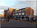
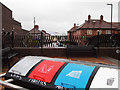
Leicester Street, Bedworth
Shops, including a florist and a newsagent, line the eastern side of Leicester Street on the edge of the town centre.
Image: © Stephen McKay
Taken: 18 Nov 2021
0.02 miles
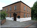
3
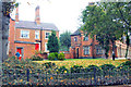
Almshouses, Bedworth
Nicholas Chamberlaine Almshouses in autumn.
Image: © Niki Walton
Taken: 12 Oct 2007
0.03 miles
4
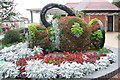
Floral Water Jug, Bedworth Town Centre
This jug has water flowing from its spout (hidden in this picture). An act of psychological encouragement, maybe, given that the building behind contains public toilets.
Image: © Niki Walton
Taken: 12 Oct 2007
0.03 miles
5
Chapel Street, Bedworth
The town centre end of Chapel Street has long been closed off. A seating area has been created with the recent addition of the bins for recycling and waste seen in the foreground.
Image: © Niki Walton
Taken: 14 Nov 2015
0.03 miles
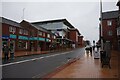
6
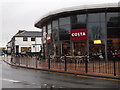
Costa Coffee
On the corner of Mill Street and Leicester Street, Bedworth
Image: © Niki Walton
Taken: 14 Nov 2015
0.04 miles
7
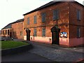
Old Meeting Congregational Chapel (now United Reformed Church)
Basking in the late afternoon summer sun and the shade of a monkey puzzle tree. The congregation's first minister was Julius Saunders in 1676. The chapel was built in 1726, altered and extended later and restored in 2012. It is the oldest complete building in central Bedworth (the parish church has an older tower, but the body of the church was rebuilt in the late 19th century). https://www.bedworth-society.co.uk/bedworth-town-trail https://historicengland.org.uk/services-skills/grants/visit/old-meeting-united-reformed-church-bedworth-cv12-8ah/
Image: © A J Paxton
Taken: 5 Jun 2021
0.04 miles
8
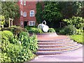
Roanne Garden, corner of Chapel Street and Leicester Street, Bedworth
Garden in the town centre of Bedworth, next to the Nicholas Chamberlaine almshouses. A small sign in the garden describes it as the Roanne Garden and explains that it was opened in 2000 https://www.flickr.com/photos/ell-r-brown/38077602195. It neglects to mention that Roanne is the French twin town of Nuneaton & Bedworth borough https://en.wikipedia.org/wiki/Nuneaton. There is also no explanation of the jug sculpture, which an older photo on the Geograph site shows covered with a floral display. The building at the rear is the Nurse's House, part of the almshouse complex built in 1840 https://www.bedworth-society.co.uk/the-parsonage-project.
Image: © A J Paxton
Taken: 5 Jun 2021
0.04 miles
9
United Reformed Church
The Old Meeting United Reformed Church, to give it its full title, in Bedworth was founded in 1686.
Image: © Michael Patterson
Taken: 3 Jul 2006
0.05 miles
10
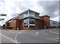
Bedworth, Tesco Extra
Supermarket and car park, seen from the corner of Leicester Street and George Street Ringway: http://www.tesco.com/store-locator/uk/?bID=6473
Image: © Mike Faherty
Taken: 8 Jun 2014
0.05 miles