IMAGES TAKEN NEAR TO
Walkers Way, BEDWORTH, CV12 0PS
Introduction
This page details the photographs taken nearby to Walkers Way, CV12 0PS by members of the Geograph project.
The Geograph project started in 2005 with the aim of publishing, organising and preserving representative images for every square kilometre of Great Britain, Ireland and the Isle of Man.

There are currently over 7.5m images from over14,400 individuals and you can help contribute to the project by visiting https://www.geograph.org.uk
Image Map
Images are licensed for reuse under creativecommons.org/licenses/by-sa/2.0
Notes
- Clicking on the map will re-center to the selected point.
- The higher the marker number, the further away the image location is from the centre of the postcode.
Image Listing (8 Images Found)
Images are licensed for reuse under creativecommons.org/licenses/by-sa/2.0
Image
Details
Distance
1
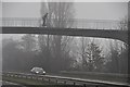
Nuneaton and Bedworth : A444 Road
A bridge over the A444 in Warwickshire.
Image: © Lewis Clarke
Taken: 6 Feb 2012
0.13 miles
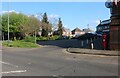
2
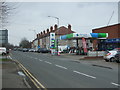
Service station on Heath Road, Bedworth Heath
Image: © JThomas
Taken: 11 Mar 2017
0.18 miles
3
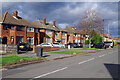
Heath Road, Bedworth Heath
A line of smart-looking semi-detached houses run along the west side of Heath Road in the outskirts of Bedworth.
Image: © Stephen McKay
Taken: 18 Nov 2022
0.18 miles
5
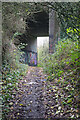
Footpath bridge under the A444
This seems a very substantial bridge to carry the Bedworth by-pass over a footpath. In fact when the road was built in the 1970s there was a railway here - the Newdigate Colliery Railway. The colliery was closed in 1982 and the railway would have done so, probably shortly afterwards, when all remaining coal stocks had been removed.
Image: © Stephen McKay
Taken: 18 Nov 2022
0.20 miles
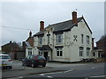
8
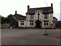
The Cross Keys, Goodyers End, Bedworth
The Cross Keys public house, or former public house, is a prominent local landmark, standing at the junction of Bowling Green Lane, Goodyers End Lane and Heath Road. It is dated 1898 on the facade. The site is now fenced off.
Image: © A J Paxton
Taken: 19 Jun 2021
0.24 miles