IMAGES TAKEN NEAR TO
Bantam Way, NUNEATON, CV11 6YG
Introduction
This page details the photographs taken nearby to Bantam Way, CV11 6YG by members of the Geograph project.
The Geograph project started in 2005 with the aim of publishing, organising and preserving representative images for every square kilometre of Great Britain, Ireland and the Isle of Man.

There are currently over 7.5m images from over14,400 individuals and you can help contribute to the project by visiting https://www.geograph.org.uk
Image Map
Images are licensed for reuse under creativecommons.org/licenses/by-sa/2.0
Notes
- Clicking on the map will re-center to the selected point.
- The higher the marker number, the further away the image location is from the centre of the postcode.
Image Listing (5 Images Found)
Images are licensed for reuse under creativecommons.org/licenses/by-sa/2.0
Image
Details
Distance
2
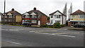
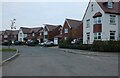
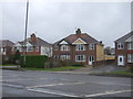
Houses on the Long Shoot in Nuneaton
The Long Shoot (A47) heads east out of Nuneaton towards Hinckley. The detached housing in this photograph is typical of private residences in this affluent suburb.
Image: © Peter Mackenzie
Taken: 9 Jan 2017
0.23 miles