IMAGES TAKEN NEAR TO
Pickford Close, NUNEATON, CV11 6UN
Introduction
This page details the photographs taken nearby to Pickford Close, CV11 6UN by members of the Geograph project.
The Geograph project started in 2005 with the aim of publishing, organising and preserving representative images for every square kilometre of Great Britain, Ireland and the Isle of Man.

There are currently over 7.5m images from over14,400 individuals and you can help contribute to the project by visiting https://www.geograph.org.uk
Image Map (Loading...)


Getting Data...Please wait
Leaflet Map data © OpenStreetMap
Images are licensed for reuse under creativecommons.org/licenses/by-sa/2.0
Notes
- Clicking on the map will re-center to the selected point.
- The higher the marker number, the further away the image location is from the centre of the postcode.
Image Listing (6 Images Found)
Images are licensed for reuse under creativecommons.org/licenses/by-sa/2.0
Image
Details
Distance
2
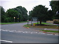
Pauls Land
30 Acres of Public Open space given to the town by Mr F A & Miss E G Paul.
Including Play area, football pitches etc.
Image: © Ian Dunckley
Taken: 31 Jul 2005
0.19 miles
3
Pauls Land
Entrance to Pauls Land from the B4114, the Lutterworth road
Image: © Beryl Allcoat
Taken: 8 Jul 2008
0.21 miles
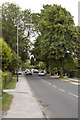
4
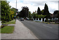
'Road into Nuneaton'
B4114, The Lutterworth Rd. Attleborough
Image: © Beryl Allcoat
Taken: 8 Jul 2008
0.21 miles
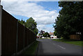
5
Attleborough, Lutterworth Road
B4114 Nuneaton to Lutterworth
Image: © Beryl Allcoat
Taken: 3 Jul 2008
0.22 miles
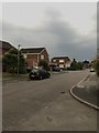
6
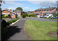
Attleborough Housing Estate
Chartwell Close
Image: © Beryl Allcoat
Taken: 8 Jul 2008
0.23 miles