IMAGES TAKEN NEAR TO
Burton Hastings, NUNEATON, CV11 6RL
Introduction
This page details the photographs taken nearby to CV11 6RL by members of the Geograph project.
The Geograph project started in 2005 with the aim of publishing, organising and preserving representative images for every square kilometre of Great Britain, Ireland and the Isle of Man.

There are currently over 7.5m images from over14,400 individuals and you can help contribute to the project by visiting https://www.geograph.org.uk
Image Map
Images are licensed for reuse under creativecommons.org/licenses/by-sa/2.0
Notes
- Clicking on the map will re-center to the selected point.
- The higher the marker number, the further away the image location is from the centre of the postcode.
Image Listing (51 Images Found)
Images are licensed for reuse under creativecommons.org/licenses/by-sa/2.0
Image
Details
Distance
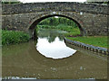
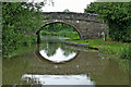
1
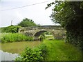
Burton Hastings, Bridge No 8
Carrying Mill Lane over Ashby Canal. The bridge is listed by Historic England: http://www.imagesofengland.org.uk/Details/Default.aspx?id=308873&mode=adv
Image: © Mike Faherty
Taken: 10 Jun 2016
0.07 miles
2
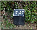
Mile marker along the Ashby Canal
Three miles from the start of the canal at Marston Junction, twenty-seven miles to Moira, although nowadays the canal terminates 19 miles away near Snarestone.
There are no locks along its entire length.
Image: © Mat Fascione
Taken: 28 Sep 2014
0.07 miles
3
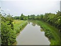
Burton Hastings, Ashby Canal
As seen from Image https://canalrivertrust.org.uk/enjoy-the-waterways/canal-and-river-network/ashby-canal
Image: © Mike Faherty
Taken: 10 Jun 2016
0.08 miles
4
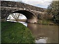
Mill Bridge (Bridge no. 8), Ashby-de-la-Zouch Canal
Bridge no. 8 carries Mill Lane over the canal, connecting the village of Burton Hastings with Burton Mill on the River Anker, here little more than a stream.
Image: © A J Paxton
Taken: 2 Apr 2023
0.08 miles
5
Mill Bridge west of Burton Hastings in Warwickshire
Mill Bridge is No 8 across the Ashby Canal, and carries Mill Lane. The watermill on the River Anker is about two hundred metres off to the right. Burton Hastings village is five hundred metres off to the left.
Image: © Roger Kidd
Taken: 18 Jun 2010
0.08 miles
6
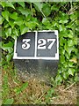
Old milemarker by the Ashby Canal, Burton Hastings
Milemarker by the Ashby Canal, in parish of Burton Hastings (Rugby District), 50m North of Bridge 8 (Mill Lane), West side of canal.
Inscription reads:-
3|27
(To Marston Junction and Moira)
Surveyed
Milestone Society National ID: ASH-03
Image: © Milestone Society
Taken: Unknown
0.08 miles
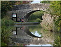
7
Ashby Canal: Bridge Number 8
Bridge Number 8 is Burton Mill Bridge and was only built to provide access over the canal to and from Burton corn mill on the River Anker. It probably dates from no later than 1804 when the canal was built. Like Image and Image its virtually original condition merits Grade II Listing status. However unlike those two it is constructed of limestone, rather than sandstone, ashlar.
Image: © Nigel Cox
Taken: 11 Jul 2013
0.08 miles
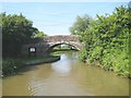
8
Bridge No 8: Mill Bridge
This bridge carries Mill Lane across the canal.
The navigable part of the Ashby Canal heads in a northerly direction for 22 miles, from its start at Marston Junction, to its terminus north of Snarestone. There are no locks along its entire length.
Image: © Mat Fascione
Taken: 28 Sep 2014
0.08 miles
9

Mill Bridge at Burton Hastings, Warwickshire
Bridge No 8 on the Ashby Canal carries the narrow lane to the old mill, about 150 metres to the west (left).
Image: © Roger D Kidd
Taken: 16 Jun 2010
0.08 miles
10
Mill Bridge west of Burton Hastings in Warwickshire
Mill Bridge is No 8 across the Ashby Canal, and carries Mill Lane. The watermill on the River Anker is about two hundred metres off to the right. Burton Hastings village is five hundred metres off to the left.
Image: © Roger Kidd
Taken: 18 Jun 2010
0.08 miles