IMAGES TAKEN NEAR TO
Lutterworth Road, NUNEATON, CV11 6RB
Introduction
This page details the photographs taken nearby to Lutterworth Road, CV11 6RB by members of the Geograph project.
The Geograph project started in 2005 with the aim of publishing, organising and preserving representative images for every square kilometre of Great Britain, Ireland and the Isle of Man.

There are currently over 7.5m images from over14,400 individuals and you can help contribute to the project by visiting https://www.geograph.org.uk
Image Map (Loading...)


Getting Data...Please wait
Leaflet Map data © OpenStreetMap
Images are licensed for reuse under creativecommons.org/licenses/by-sa/2.0
Notes
- Clicking on the map will re-center to the selected point.
- The higher the marker number, the further away the image location is from the centre of the postcode.
Image Listing (5 Images Found)
Images are licensed for reuse under creativecommons.org/licenses/by-sa/2.0
Image
Details
Distance
1
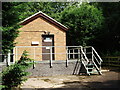
Anker Bridge Sewage Pumping Station, Thompson Road, Bramcote
Image: © John Brightley
Taken: 5 Aug 2012
0.08 miles
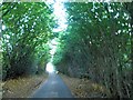
2
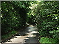
Thompson Lane, Bramcote
This road is a very narrow and overgrown country lane -only just wide enough for one car between the current hedgerows.
The road does not have any name signs, nor have I found the road name on any maps -I only found the name of the road from a Rugby Borough Council planning report for an application for a control kiosk at the sewage pumping station.
In recent years this location has been known as Bramcote, or even Wolvey, but pre World War II it was more commonly known as Wolvershill.
Image: © John Brightley
Taken: 5 Aug 2012
0.09 miles