IMAGES TAKEN NEAR TO
Meadowside, NUNEATON, CV11 6NE
Introduction
This page details the photographs taken nearby to Meadowside, CV11 6NE by members of the Geograph project.
The Geograph project started in 2005 with the aim of publishing, organising and preserving representative images for every square kilometre of Great Britain, Ireland and the Isle of Man.

There are currently over 7.5m images from over14,400 individuals and you can help contribute to the project by visiting https://www.geograph.org.uk
Image Map
Images are licensed for reuse under creativecommons.org/licenses/by-sa/2.0
Notes
- Clicking on the map will re-center to the selected point.
- The higher the marker number, the further away the image location is from the centre of the postcode.
Image Listing (8 Images Found)
Images are licensed for reuse under creativecommons.org/licenses/by-sa/2.0
Image
Details
Distance
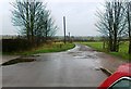
2
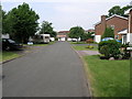
Wentworth Drive Nuneaton
The photograph shows Wentworth Drive at its junction with Golf Drive in the suburb of Whitestone, Nuneaton.
Image: © Peter Mackenzie
Taken: 17 Jan 2017
0.17 miles
4
Golf Drive, Whitestone, Nuneaton
Looking north east.
Image: © JThomas
Taken: 4 Mar 2017
0.18 miles
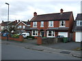
5
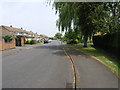
Willow Shade
The willow tree in this housing estate looks like it predates the houses by a good few years.
Image: © Michael Patterson
Taken: 12 Jun 2006
0.20 miles
6
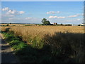
Hill Farm
View from Golf Drive looking towards Hill Farm
Image: © Ian Dunckley
Taken: 2 Aug 2005
0.20 miles
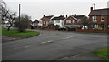
7
Corner Plot
This group of houses occupies the SW corner of this square. Just behind the houses on the right is a golf course.
Image: © Michael Patterson
Taken: 12 Jun 2006
0.23 miles
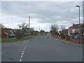
8
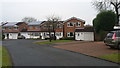
Housing in Foxhills Close Nuneaton
Foxhills Close is a quiet cul-de-sac on the outskirts of Nuneaton. The photograph shows modern housing typical of this area.
Image: © Peter Mackenzie
Taken: 17 Jan 2017
0.24 miles