IMAGES TAKEN NEAR TO
The Parade, Princes Street, NUNEATON, CV11 5NR
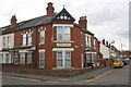
Introduction
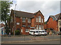
This page details the photographs taken nearby to The Parade, Princes Street, CV11 5NR by members of the Geograph project.
The Geograph project started in 2005 with the aim of publishing, organising and preserving representative images for every square kilometre of Great Britain, Ireland and the Isle of Man.

There are currently over 7.5m images from over14,400 individuals and you can help contribute to the project by visiting https://www.geograph.org.uk
Image Map
Images are licensed for reuse under creativecommons.org/licenses/by-sa/2.0
Notes
- Clicking on the map will re-center to the selected point.
- The higher the marker number, the further away the image location is from the centre of the postcode.
Image Listing (82 Images Found)
Images are licensed for reuse under creativecommons.org/licenses/by-sa/2.0
Image
Details
Distance
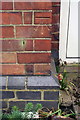
1
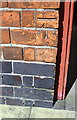
Benchmark on #51 Princes Street
Ordnance Survey cut mark benchmark described on the Bench Mark Database at http://www.bench-marks.org.uk/bm74891
Image: © Roger Templeman
Taken: 5 Apr 2016
0.07 miles
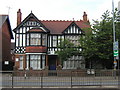
2
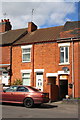
Houses on Princes Street
There is an Ordnance Survey benchmark Image below the #51 number sign left of the alleyway entrance (obscured by car boot)
Image: © Roger Templeman
Taken: 5 Apr 2016
0.07 miles
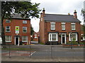
3
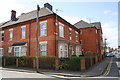
Houses at bend in Princes Street
There is an OS benchmark Image on the near corner, left hand face (behind hedge) of this former pub
Image: © Roger Templeman
Taken: 5 Apr 2016
0.07 miles
4
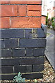
Benchmark on Harcourt Villa
Ordnance Survey cut mark benchmark described on the Bench Mark Database at http://www.bench-marks.org.uk/bm74887
Image: © Roger Templeman
Taken: 5 Apr 2016
0.07 miles
5
'Edward House' at Edward Street / Frank Street junction
There is an OS benchmark Image on the right hand face of the house, left of a white door
Image: © Roger Templeman
Taken: 5 Apr 2016
0.07 miles
6
Benchmark on #159 Edward Street
Ordnance Survey cut mark described on the Bench Mark Database at http://www.bench-marks.org.uk/bm74892
Image: © Roger Templeman
Taken: 5 Apr 2016
0.08 miles
7
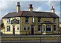
The Rose Inn in Nuneaton
A Marston's public house along the A444 Coton Road.
Image: © Mat Fascione
Taken: 28 Sep 2014
0.09 miles
8
24a and 25 Coton Road, Nuneaton
Offices occupied by 'RF Sharrott & Co' (24a, on the right, on the corner of Riversley Road), and 'Primary Care' (25, on the left).
Image: © John Brightley
Taken: 7 Jun 2003
0.10 miles
10
'Catering Alliance' offices, Coton Road
This was previously the original 'Red Roofs' doctors surgery until the new building was built further down the road.
Image: © John Brightley
Taken: 7 Jun 2003
0.10 miles