IMAGES TAKEN NEAR TO
Borough Way, NUNEATON, CV11 5JN
Introduction
This page details the photographs taken nearby to Borough Way, CV11 5JN by members of the Geograph project.
The Geograph project started in 2005 with the aim of publishing, organising and preserving representative images for every square kilometre of Great Britain, Ireland and the Isle of Man.

There are currently over 7.5m images from over14,400 individuals and you can help contribute to the project by visiting https://www.geograph.org.uk
Image Map
Images are licensed for reuse under creativecommons.org/licenses/by-sa/2.0
Notes
- Clicking on the map will re-center to the selected point.
- The higher the marker number, the further away the image location is from the centre of the postcode.
Image Listing (62 Images Found)
Images are licensed for reuse under creativecommons.org/licenses/by-sa/2.0
Image
Details
Distance
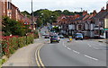
1
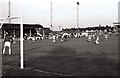
Manor Park - Former home of Nuneaton Borough
Image: © Steve Daniels
Taken: 10 Aug 1982
0.01 miles

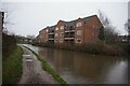
4
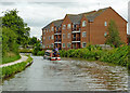
Canalside apartments near Nuneaton in Warwickshire
Looking south-east.
The apartment block is off Tomkinson Road near Wash Lane Bridge, No 21.
Jo Turner writes:
Image: © Roger D Kidd
Taken: 19 Aug 2013
0.05 miles
5
Canalside apartments near Nuneaton in Warwickshire
Looking south-east.
The apartment block is off Tomkinson Road near Wash Lane Bridge, No 21.
Jo Turner writes:
Image: © Roger D Kidd
Taken: 19 Aug 2013
0.05 miles
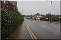
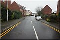
9
Housing near Wash Lane Bridge
On the Coventry Canal.
Image: © Andrew Abbott
Taken: 2 May 2023
0.06 miles
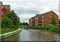
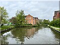
10

Coventry Canal from Wash Lane Bridge
Image: © Alex McGregor
Taken: 17 Jul 2014
0.06 miles