IMAGES TAKEN NEAR TO
Meadow Street, NUNEATON, CV11 5JF
Introduction
This page details the photographs taken nearby to Meadow Street, CV11 5JF by members of the Geograph project.
The Geograph project started in 2005 with the aim of publishing, organising and preserving representative images for every square kilometre of Great Britain, Ireland and the Isle of Man.

There are currently over 7.5m images from over14,400 individuals and you can help contribute to the project by visiting https://www.geograph.org.uk
Image Map
Images are licensed for reuse under creativecommons.org/licenses/by-sa/2.0
Notes
- Clicking on the map will re-center to the selected point.
- The higher the marker number, the further away the image location is from the centre of the postcode.
Image Listing (69 Images Found)
Images are licensed for reuse under creativecommons.org/licenses/by-sa/2.0
Image
Details
Distance
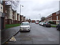
2
Houses in High Street
Typical housing of this area near the centre of Nuneaton.
Image: © Peter Mackenzie
Taken: 21 Mar 2017
0.07 miles
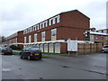
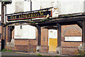
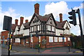
5
The Kingsholme, Nuneaton
Former public house on Abbey Street.
Image: © JThomas
Taken: 25 Feb 2017
0.10 miles
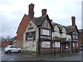
6
The Kingsholme, Nuneaton
Back in 2013 some efforts were being made to let these premises (Image) but they were evidently unsuccessful because the old pub remains empty and derelict as it has done now for more than 22 years. In fact things have only got worse. In April 2021 police found a 'huge' cannabis factory in operation inside. In 2022 there have been two arson attacks, the first in June and again just three days after this photograph was taken.
Image: © Stephen McKay
Taken: 9 Nov 2022
0.10 miles
7
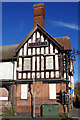
The Kingsholme, Nuneaton
This former Ansells pub has been derelict since 2000, all attempts to sell or let it having apparently failed. It had been known as the Coach and Horses until 1994. Despite plans to demolish it and build a new petrol station on the site in about 2013, it remains empty and in 2021 police discovered a 'huge' cannabis factory operating inside. It has also been subject to several arson attacks.
Image: © Stephen McKay
Taken: 9 Nov 2022
0.10 miles
8
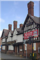
The Kingsholme, Nuneaton
This former Ansells pub, once known as the Coach and Horses, has been derelict since 2000. Despite repeated efforts by the council nothing has yet been done to redevelop the site.
Image: © Stephen McKay
Taken: 20 Jul 2013
0.10 miles
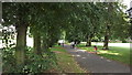
9
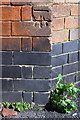
Benchmark on 'The Kingsholme' pub
Ordnance Survey cut mark benchmark described on the Bench Mark Database at http://www.bench-marks.org.uk/bm79382
Image: © Roger Templeman
Taken: 30 Sep 2016
0.10 miles
10
'The Kingsholme', Abbey Street
There is an OS benchmark Image on the near corner, left hand face, of the closed pub
Image: © Roger Templeman
Taken: 30 Sep 2016
0.10 miles