IMAGES TAKEN NEAR TO
Corporation Street, NUNEATON, CV11 5BG
Introduction
This page details the photographs taken nearby to Corporation Street, CV11 5BG by members of the Geograph project.
The Geograph project started in 2005 with the aim of publishing, organising and preserving representative images for every square kilometre of Great Britain, Ireland and the Isle of Man.

There are currently over 7.5m images from over14,400 individuals and you can help contribute to the project by visiting https://www.geograph.org.uk
Image Map
Images are licensed for reuse under creativecommons.org/licenses/by-sa/2.0
Notes
- Clicking on the map will re-center to the selected point.
- The higher the marker number, the further away the image location is from the centre of the postcode.
Image Listing (63 Images Found)
Images are licensed for reuse under creativecommons.org/licenses/by-sa/2.0
Image
Details
Distance
1
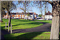
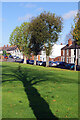
Abbey Gardens, Nuneaton
Abbey Gardens is an open space that runs alongside Corporation Street just off Nuneaton town centre.
Image: © Stephen McKay
Taken: 9 Nov 2022
0.02 miles
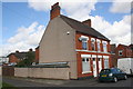
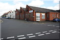
2
Corporation Street, Nuneaton
Nowadays the B4114, but this was originally the A47.
Image: © Stephen McKay
Taken: 20 Jul 2013
0.03 miles
3
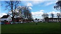
Abbey Gardens, Nuneaton
The name of this open space near Nuneaton town centre is a reminder that the town was once a monastic centre. In 1155 a Benedictine priory was established here at what was then simply called Eaton. An abbey church was also built. There was a significant women's house as part of the priory which led to the 'Nun' part of Nuneaton's name. The priory was dissolved by Henry VIII in common with other monastic establishments in England.
Image: © Stephen McKay
Taken: 9 Nov 2022
0.04 miles
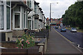
4
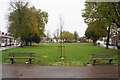
Abbey Green
This small patch of green grass is what gives Abbey Green its name.
Image: © Peter Mackenzie
Taken: 21 Mar 2017
0.04 miles
6
Abbey Green
A small distance from an old street with the same name. In the foreground is a tree planted to commemorate the 60th anniversary of the twinning in 1956 with Roanne in France.
Image: © Bill Boaden
Taken: 14 Oct 2018
0.05 miles
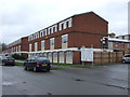
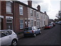
7
Cascade Textiles Ltd at Bath Road / Central Avenue junction
There is an OS benchmark Image on the near corner, left hand face, of the works.
Image: © Roger Templeman
Taken: 30 Sep 2016
0.07 miles
8
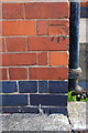
Benchmark on Bath Road textile works
Ordnance Survey cut mark benchmark described on the Bench Mark Database at http://www.bench-marks.org.uk/bm79384
Image: © Roger Templeman
Taken: 30 Sep 2016
0.07 miles