IMAGES TAKEN NEAR TO
Penshurst Way, NUNEATON, CV11 4XF
Introduction
This page details the photographs taken nearby to Penshurst Way, CV11 4XF by members of the Geograph project.
The Geograph project started in 2005 with the aim of publishing, organising and preserving representative images for every square kilometre of Great Britain, Ireland and the Isle of Man.

There are currently over 7.5m images from over14,400 individuals and you can help contribute to the project by visiting https://www.geograph.org.uk
Image Map
Images are licensed for reuse under creativecommons.org/licenses/by-sa/2.0
Notes
- Clicking on the map will re-center to the selected point.
- The higher the marker number, the further away the image location is from the centre of the postcode.
Image Listing (17 Images Found)
Images are licensed for reuse under creativecommons.org/licenses/by-sa/2.0
Image
Details
Distance
1
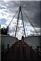
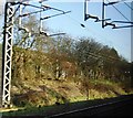
'New Age' Bridge
Bridge across the WCML at Pauls Land, Attleborough.
Image: © Beryl Allcoat
Taken: 8 Jul 2008
0.11 miles
5
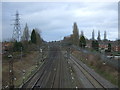
West Coast Main Line
Looking north from the bridge on Gipsy Lane.
Image: © JThomas
Taken: 4 Mar 2017
0.16 miles
6
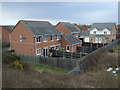
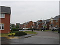
Houses on Coughton Close
Beside the West Coast Main Line.
Image: © JThomas
Taken: 4 Mar 2017
0.17 miles
7
Pauls Land
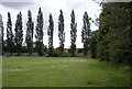
Whitestone recreation Ground
Image: © Beryl Allcoat
Taken: 8 Jul 2008
0.17 miles
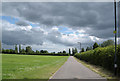
8
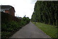
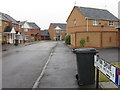
Long Walk
Pauls Land Whitestone to Marston Lane Attleborough, 0.52kmtr long
Image: © Beryl Allcoat
Taken: 8 Jul 2008
0.19 miles
9
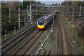
West Coast Main Line, Whitestone
A Liverpool - Euston Pendolino passes Attleborough South Junction on its way between Nuneaton and Rugby.
Image: © Stephen McKay
Taken: 2 Feb 2014
0.19 miles