IMAGES TAKEN NEAR TO
Barne Close, NUNEATON, CV11 4TP
Introduction
This page details the photographs taken nearby to Barne Close, CV11 4TP by members of the Geograph project.
The Geograph project started in 2005 with the aim of publishing, organising and preserving representative images for every square kilometre of Great Britain, Ireland and the Isle of Man.

There are currently over 7.5m images from over14,400 individuals and you can help contribute to the project by visiting https://www.geograph.org.uk
Image Map
Images are licensed for reuse under creativecommons.org/licenses/by-sa/2.0
Notes
- Clicking on the map will re-center to the selected point.
- The higher the marker number, the further away the image location is from the centre of the postcode.
Image Listing (33 Images Found)
Images are licensed for reuse under creativecommons.org/licenses/by-sa/2.0
Image
Details
Distance
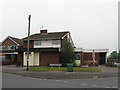
2
Chetwynd Drive, Nuneaton
The photograph captures typical housing in this suburban part of Nuneaton.
Image: © Peter Mackenzie
Taken: 4 Jan 2017
0.08 miles
3
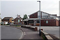
The Chetwynd Arms, Whitestone
This suburban area of Nuneaton was developed in the late 1960s/early 1970s and the Chetwynd Arms - a typical estate pub - was built to serve it.
Image: © Stephen McKay
Taken: 26 Jul 2021
0.09 miles
5
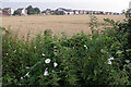
Farmland south of Whitestone
Bindweed, with its white flowers, has infested the hedgerow in the foreground. Beyond that, across the field, is the Chetwynd pub and houses on Chetwynd Drive.
Image: © Stephen McKay
Taken: 26 Jul 2021
0.13 miles
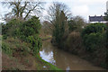
6
Ashby Canal south of Whitestone in Nuneaton, Warwickshire
Looking west as the Ashby Canal meanders towards Marston Junction and Bedworth. Bulkington Lane Bridge (No 5) is just beyond the bend ahead.
Image: © Roger Kidd
Taken: 18 Jun 2010
0.20 miles
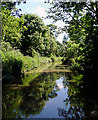
7
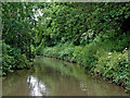
Ashby Canal, near Bulkington
Trees are reflected in the water of the Ashby Canal just east of Bulking Road Bridge in this early morning view.
Image: © Stephen McKay
Taken: 26 Jul 2021
0.20 miles
8
Ashby-de-la-Zouch Canal by Mill Farm Park, Bulkington
Mill Farm Park is a development of mobile homes (or 'park homes', as they are called on estate agents' sites) on the site of a former quarry by the Ashby Canal, just east of Bridge no. 5, which carries the road from Bulkington to Nuneaton over the canal.
Image: © A J Paxton
Taken: 2 Apr 2023
0.21 miles
9
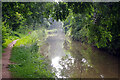
Ashby Canal from Bulkington Lane Bridge
The Ashby Canal passes under bridge 5 near Bulkington and winds its way towards Hinckley.
Image: © Stephen McKay
Taken: 2 Feb 2014
0.21 miles
10
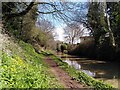
The Ashby Canal near Whitestone, Warwickshire
This 22 mile lock free canal originally went as far north as Conkers (near Moira), and never reached Ashby-de-la-Zouch. Coal was carried on a regular commercial basis until the 1960s. At present the canal stops at Snarestone, though the eight mile stretch to Moira is being (or has been) restored.
Image: © Roger D Kidd
Taken: 16 Jun 2010
0.21 miles