IMAGES TAKEN NEAR TO
Simon Close, NUNEATON, CV11 4JR
Introduction
This page details the photographs taken nearby to Simon Close, CV11 4JR by members of the Geograph project.
The Geograph project started in 2005 with the aim of publishing, organising and preserving representative images for every square kilometre of Great Britain, Ireland and the Isle of Man.

There are currently over 7.5m images from over14,400 individuals and you can help contribute to the project by visiting https://www.geograph.org.uk
Image Map (Loading...)


Getting Data...Please wait
Leaflet Map data © OpenStreetMap
Images are licensed for reuse under creativecommons.org/licenses/by-sa/2.0
Notes
- Clicking on the map will re-center to the selected point.
- The higher the marker number, the further away the image location is from the centre of the postcode.
Image Listing (28 Images Found)
Images are licensed for reuse under creativecommons.org/licenses/by-sa/2.0
Image
Details
Distance
1
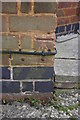
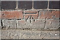
Benchmark on #150 Attleborough Road
Ordnance Survey cut mark benchmark described on the Bench Mark Database at http://www.bench-marks.org.uk/bm74904
Image: © Roger Templeman
Taken: 9 Apr 2016
0.06 miles
2
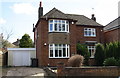
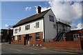
#150 Attleborough Road
There is an OS benchmark Image on the left hand side of the house at its front corner
Image: © Roger Templeman
Taken: 9 Apr 2016
0.06 miles
3
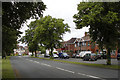
Attleborough, Highfield Road
B4114 to Nuneaton
Image: © Beryl Allcoat
Taken: 11 Jul 2008
0.08 miles
4
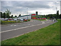
The Pingles
In April 2000 Nuneaton and Bedworth Borough Council were awarded a £2,900,000 lottery award to construct a £7,000,000 leisure centre to replace the existing Pingles Leisure Centre.
In November 2003 the old Pingles was razed to the ground to provide the landscaped car parking, with the final completion of the project in early 2004.
Image: © Ian Dunckley
Taken: 3 Aug 2005
0.09 miles
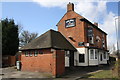
5
'The Fuzzy Duck', Attleborough Road
There is an OS benchmark Image on the front on the pub about 2 feet right of the blocked doorway
Image: © Roger Templeman
Taken: 9 Apr 2016
0.10 miles
6
Benchmark on 'The fuzzy Duck'
Ordnance Survey cut mark benchmark described on the Bench Mark Database at http://www.bench-marks.org.uk/bm74901
Image: © Roger Templeman
Taken: 9 Apr 2016
0.10 miles
9
The Bull & Spice, Avenue Road
There is an OS benchmark Image on the near angle, right hand face, of the main pub building
Image: © Roger Templeman
Taken: 9 Apr 2016
0.15 miles
10
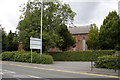
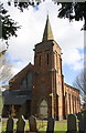
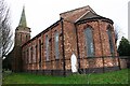
Attleborough Holy Trinity Church
Built as a 'Chapel of Ease' of Nuneaton St Nicholas, for the Ribbon and Silk workers
Image: © Beryl Allcoat
Taken: 11 Jul 2008
0.15 miles