
IMAGES TAKEN NEAR TO
Conwy Close, NUNEATON, CV11 4FS
Introduction
This page details the photographs taken nearby to Conwy Close, CV11 4FS by members of the Geograph project.
The Geograph project started in 2005 with the aim of publishing, organising and preserving representative images for every square kilometre of Great Britain, Ireland and the Isle of Man.

There are currently over 7.5m images from over14,400 individuals and you can help contribute to the project by visiting https://www.geograph.org.uk
Image Map
Images are licensed for reuse under creativecommons.org/licenses/by-sa/2.0
Notes
- Clicking on the map will re-center to the selected point.
- The higher the marker number, the further away the image location is from the centre of the postcode.
Image Listing (33 Images Found)
Images are licensed for reuse under creativecommons.org/licenses/by-sa/2.0
Image
Details
Distance
1
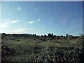
Between the lines
Uncultivated land between the Birmingham to Leicester line and the West Coast main line as seen from the Cornish Riviera Statesman excursion train as it approached Nuneaton South Junction
Image: © Tim Glover
Taken: 25 Sep 2020
0.09 miles
2
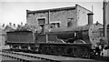
Ex-Midland Johnson 2F 0-6-0 at Nuneaton Locomotive Depot
No. 58240 (formerly LMS No. 3161) probably did not turn a wheel after this photograph, as it was withdrawn in 5/53. It was one of the Johnson 4'11" 2F 0-6-0s in original form with round-top boiler - see Image
Image: © Ben Brooksbank
Taken: 15 Mar 1953
0.12 miles
3
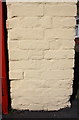
Benchmark on shed next to #2 Gadsby Street
Ordnance Survey cut mark benchmark described on the Bench Mark Database at http://www.bench-marks.org.uk/bm74899
Image: © Roger Templeman
Taken: 9 Apr 2016
0.12 miles
4
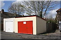
Sheds on Gadsby Street
There is an OS benchmark Image on the bricks on the right hand side of the red door
Image: © Roger Templeman
Taken: 9 Apr 2016
0.12 miles
5
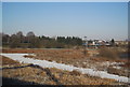
Wasteland between the West Coast Main Line and the Leicester line
Image: © N Chadwick
Taken: 19 Dec 2010
0.13 miles
7
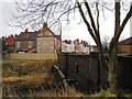
Attleborough Road river bridge, Nuneaton
The road bridge over the River Anker, which flows from left to right to run through Riversley Park just a short distance further downstream.
Note the old painted advert in the background.
Image: © John Brightley
Taken: 26 Feb 2005
0.14 miles
8
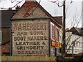
Old advertising sign, Attleborough Road, Nuneaton
Advertising ' W.A.Herbert and Sons, Boot Makers, Leather & Grindery Dealers', this sign (on the side of a shop which is now the Golden Bridge chinese takeaway) was covered by a modern advertising hoarding for many years until being uncovered shortly before this photo was taken.
Possibly the best surviving painted sign in Warwickshire.
Image: © John Brightley
Taken: 26 Feb 2005
0.14 miles
9
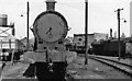
Nuneaton Locomotive Depot
View NE in the Locomotive Yard - 'about to be attacked by' ex-London & North Western 0-8-0 No. 49047! This was an important freight Depot for the West Coast Main Line and its connections at Trent Valley Station, also catering for local passenger services. It was located between the WCML and the line to Coventry. Coded by the LMSR and BR as 2B (Rugby District), it had an allocation of 69 locomotives in 1954:- 3 4-4-0s, 15 2-8-0s, 14 2-6-0s, 18 0-8-0s, 7 0-6-0s, 8 2-6-2Ts and 4 0-6-0Ts. It closed in 6/66.
Image: © Ben Brooksbank
Taken: 15 Mar 1953
0.15 miles
10
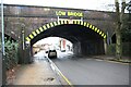
Railway bridge over Attleborough Road (B4114)
There is an Ordnance Survey benchmark Image on the left hand side of the bridge arch right of a downpipe
Image: © Luke Shaw
Taken: 31 Jan 2020
0.15 miles