IMAGES TAKEN NEAR TO
King Edward Road, NUNEATON, CV11 4BQ
Introduction
This page details the photographs taken nearby to King Edward Road, CV11 4BQ by members of the Geograph project.
The Geograph project started in 2005 with the aim of publishing, organising and preserving representative images for every square kilometre of Great Britain, Ireland and the Isle of Man.

There are currently over 7.5m images from over14,400 individuals and you can help contribute to the project by visiting https://www.geograph.org.uk
Image Map
Images are licensed for reuse under creativecommons.org/licenses/by-sa/2.0
Notes
- Clicking on the map will re-center to the selected point.
- The higher the marker number, the further away the image location is from the centre of the postcode.
Image Listing (146 Images Found)
Images are licensed for reuse under creativecommons.org/licenses/by-sa/2.0
Image
Details
Distance
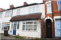
1
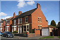
Houses on King Edward Road
There is an OS benchmark Image on the side of the near house, #48 'South View', about 3ft. inside its wooden side gate
Image: © Roger Templeman
Taken: 9 Apr 2016
0.02 miles
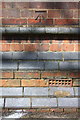
2
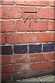
Benchmark on #48 King Edward Road
Ordnance Survey cut mark benchmark described on the Bench Mark Database at http://www.bench-marks.org.uk/bm74914
Image: © Roger Templeman
Taken: 9 Apr 2016
0.03 miles
3
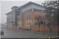
Nuneaton : Warwickshire Justice Centre
A justice centre for Warwickshire on Vicarage Street.
Image: © Lewis Clarke
Taken: 6 Feb 2012
0.07 miles
4
Benchmark on #68 Wheat Street
Ordnance Survey cut mark benchmark described on the Bench Mark Database at http://www.bench-marks.org.uk/bm63443
Image: © Roger Templeman
Taken: 4 Jan 2015
0.08 miles
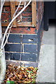
5
#68 Wheat Street
There is an OS benchmark Image behind the bottom of the trellis left of the archway door
Image: © Roger Templeman
Taken: 4 Jan 2015
0.08 miles
6
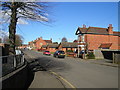
King Edward Road, Nuneaton
King Edward's School is behind the railing on the left.
Image: © John Brightley
Taken: 19 Feb 2005
0.08 miles
7
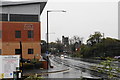
Vicarage Street on a wet day
Part of the inner ring road passing the Justice Centre. The parish church is in the background.
Image: © Bill Boaden
Taken: 14 Oct 2018
0.08 miles
8
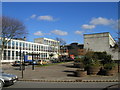
Justice Centre and Police Station, Nuneaton.
A view from Church Street which was not like this for very long.
The new red-brick Justice Centre in the background was in the process of being completed. The police would soon move there from the 1960's police station which is the light-coloured tower block which can be seen to the left of the Justice Centre in this photo. Shortly after the police's move the old police station was demolished.
Image: © John Brightley
Taken: 19 Feb 2005
0.09 miles
9
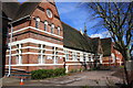
King Edward School VI (SE face)
There is an OS benchmark Image on the jut under the bell spire
Image: © Roger Templeman
Taken: 9 Apr 2016
0.10 miles
10
Benchmark on King Edward School
Ordnance Survey cut mark benchmark described on the Bench Mark Database at http://www.bench-marks.org.uk/bm74913
Image: © Roger Templeman
Taken: 9 Apr 2016
0.10 miles