IMAGES TAKEN NEAR TO
Nuthurst Crescent, NUNEATON, CV10 9PJ
Introduction
This page details the photographs taken nearby to Nuthurst Crescent, CV10 9PJ by members of the Geograph project.
The Geograph project started in 2005 with the aim of publishing, organising and preserving representative images for every square kilometre of Great Britain, Ireland and the Isle of Man.

There are currently over 7.5m images from over14,400 individuals and you can help contribute to the project by visiting https://www.geograph.org.uk
Image Map
Images are licensed for reuse under creativecommons.org/licenses/by-sa/2.0
Notes
- Clicking on the map will re-center to the selected point.
- The higher the marker number, the further away the image location is from the centre of the postcode.
Image Listing (16 Images Found)
Images are licensed for reuse under creativecommons.org/licenses/by-sa/2.0
Image
Details
Distance
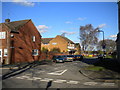
1
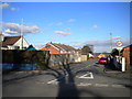
Nuthurst Crescent, Ansley village
Presumably the 3 ton maximum gross weight restriction is intended to prevent large vehicles from using Nuthurst Crescent as a short cut from Birmingham Road (foreground) to Tunnel Road.
Image: © Richard Vince
Taken: 2 Feb 2013
0.06 miles
2
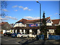
The Lord Nelson and Victory Restaurant, Ansley village
A pub and restaurant, connected in name as well as apparently in management, on Birmingham Road in Ansley.
Image: © Richard Vince
Taken: 2 Feb 2013
0.07 miles
3

The Lord Nelson Inn, Ansley - CAMRA awards
These are just some of the many awards the Lord Nelson and its associated Sperrin Brewery have received over the years from CAMRA (Campaign for Real Ale). The certificates are proudly displayed inside the pub.
Image: © Stephen McKay
Taken: 2 Nov 2022
0.07 miles
4
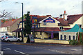
The Lord Nelson Inn, Ansley
The Lord Nelson Inn in Ansley village is a true free house, family owned - as it has been for many years - and not in the hands of a pub company or other corporate entity. Consequently it can pursue its own policies which include brewing its own beers (the Sperrin brewery). Ansley is lucky to have such a place within its community.
Image: © Stephen McKay
Taken: 2 Nov 2022
0.08 miles
5
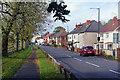
Birmingham Road, Ansley
Looking along the main road through Ansley village, a stretch of the B4112, from close to the Lord Nelson Inn.
Image: © Stephen McKay
Taken: 2 Nov 2022
0.10 miles
6
Croft Mead, Ansley village
A residential cul de sac off Birmingham Road in Ansley.
Image: © Richard Vince
Taken: 2 Feb 2013
0.11 miles
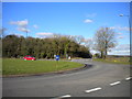
7
South end of Birmingham Road, Ansley
Looking into Ansley village from the roundabout along Birmingham Road.
Image: © Richard Vince
Taken: 2 Feb 2013
0.12 miles
8
Looking north across Ansley roundabout
Looking across Ansley roundabout towards the south end of Tunnel Road, which leads to Galley Common. Tunnel Road is so called because it crosses Arley Tunnel, which takes the former Midland Railway line from Nuneaton to Birmingham under the high ground in this area.
Image: © Richard Vince
Taken: 2 Feb 2013
0.12 miles
9
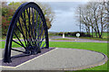
Daw Mill Mining Memorial
Warwickshire never had a high profile as a mining county compared with the likes of Yorkshire, Durham or Glamorgan. Yet it was important right to the end - Daw Mill was one of the very last deep coal mines in Britain to close. It finally did so in 2013, a year earlier than planned due to an underground fire, with the loss of about 650 jobs. In 2017 one half of one of the pit wheels was erected as a memorial here in the middle of a traffic roundabout on the edge of Ansley village. Mining is a just a memory now in these parts but not one that will be easily forgotten. See this YouTube video for more information: https://www.youtube.com/watch?v=7JfQNORlvb0.
Image: © Stephen McKay
Taken: 2 Nov 2022
0.13 miles
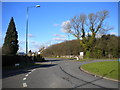
10
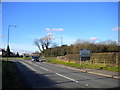
Approaching Ansley roundabout
Approaching Ansley roundabout along Ansley Road.
Image: © Richard Vince
Taken: 2 Feb 2013
0.14 miles