IMAGES TAKEN NEAR TO
Beverley Avenue, NUNEATON, CV10 9JR
Introduction
This page details the photographs taken nearby to Beverley Avenue, CV10 9JR by members of the Geograph project.
The Geograph project started in 2005 with the aim of publishing, organising and preserving representative images for every square kilometre of Great Britain, Ireland and the Isle of Man.

There are currently over 7.5m images from over14,400 individuals and you can help contribute to the project by visiting https://www.geograph.org.uk
Image Map
Images are licensed for reuse under creativecommons.org/licenses/by-sa/2.0
Notes
- Clicking on the map will re-center to the selected point.
- The higher the marker number, the further away the image location is from the centre of the postcode.
Image Listing (14 Images Found)
Images are licensed for reuse under creativecommons.org/licenses/by-sa/2.0
Image
Details
Distance
1
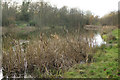
Whytell Pool
This pond has the feeling of being quite remote although in reality it is not far from housing. The area is managed by Nuneaton and Bedworth Borough Council as a nature and wildlife park and can be accessed via a path leading off Beverley Avenue.
Image: © Stephen McKay
Taken: 6 Dec 2017
0.06 miles
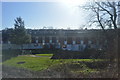
3
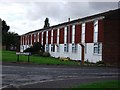
404-412 Kingswood Road, Stockingford, Nuneaton
Built as council houses - I believe in the late 1960's or early 1970's.
Image: © John Brightley
Taken: 20 Sep 2010
0.16 miles
4
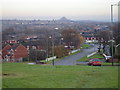
Thorntons Way, Stockingford, Nuneaton
The immediate view is of Thorntons Way, looking out across Camp Hill, towards the Granite Quarries in Nuneaton.
Image: © peter lloyd
Taken: 7 Dec 2005
0.18 miles
5
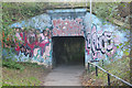
Subway to Kingswood Road
The subway provides a pedestrian route under the Nuneaton - Birmingham railway. It looks a complete mess.
Image: © Stephen McKay
Taken: 6 Dec 2017
0.18 miles
6
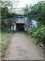
Subway From Beverley Avenue to Kingswood Road
Underpass from Beverley Avenue to Kingswood Road.
Image: © Neil Goodwin
Taken: 26 Apr 2020
0.18 miles
7
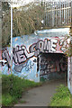
Subway to Beverley Avenue
The subway provides a pedestrian route under the Nuneaton - Birmingham railway connecting Stockingford with Whittleford. The graffiti says 'welcome' but it does not look very welcoming.
Image: © Stephen McKay
Taken: 6 Dec 2017
0.19 miles
8
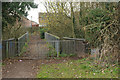
Bridge over the Black Track
The footbridge passes over the Black Track, a former colliery branch line. The bridge connects Selby Way with Chaucer Drive.
Image: © Stephen McKay
Taken: 6 Dec 2017
0.20 miles
9
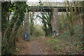
The Black Track
The Black Track was a railway built in 1876 to serve Stockingford and Ansley Hall collieries. It was abandoned in 1964 and is now a footpath. Note that murals - celebrating the local coal industry - have been painted at the foot of the bridge piers.
Image: © Stephen McKay
Taken: 6 Dec 2017
0.20 miles
10
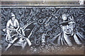
Mural on the Black Track
The Black Track was a railway built in 1876 to serve Stockingford and Ansley Hall collieries. It was abandoned in 1964 and is now a footpath. Under the bridge by Selby Way are murals celebrating the local mining industry.
Image: © Stephen McKay
Taken: 6 Dec 2017
0.21 miles