IMAGES TAKEN NEAR TO
Long Kiln Road, NUNEATON, CV10 9GG
Introduction
This page details the photographs taken nearby to Long Kiln Road, CV10 9GG by members of the Geograph project.
The Geograph project started in 2005 with the aim of publishing, organising and preserving representative images for every square kilometre of Great Britain, Ireland and the Isle of Man.

There are currently over 7.5m images from over14,400 individuals and you can help contribute to the project by visiting https://www.geograph.org.uk
Image Map (Loading...)


Getting Data...Please wait
Leaflet Map data © OpenStreetMap
Images are licensed for reuse under creativecommons.org/licenses/by-sa/2.0
Notes
- Clicking on the map will re-center to the selected point.
- The higher the marker number, the further away the image location is from the centre of the postcode.
Image Listing (3 Images Found)
Images are licensed for reuse under creativecommons.org/licenses/by-sa/2.0
Image
Details
Distance
1
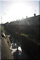
Camp Hill houses
A row of (mostly derelict) houses in Camp Hill, Nuneaton.
Image: © Richard Harrison
Taken: 20 Jan 2006
0.11 miles
2
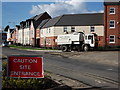
New housing, Queen Elizabeth Road, Camp Hill, Nuneaton
Brand new housing built by Barratt as part of a large scale redevelopment of the area.
Image: © John Brightley
Taken: 20 Sep 2010
0.16 miles
3
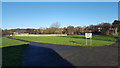
Park and Pond
This small park and duck pond provide welcome recreation space to the west of Camp Hill, Nuneaton.
Image: © Peter Mackenzie
Taken: 28 Nov 2017
0.24 miles