IMAGES TAKEN NEAR TO
Malvern Avenue, NUNEATON, CV10 8ND
Introduction
This page details the photographs taken nearby to Malvern Avenue, CV10 8ND by members of the Geograph project.
The Geograph project started in 2005 with the aim of publishing, organising and preserving representative images for every square kilometre of Great Britain, Ireland and the Isle of Man.

There are currently over 7.5m images from over14,400 individuals and you can help contribute to the project by visiting https://www.geograph.org.uk
Image Map (Loading...)


Getting Data...Please wait
Leaflet Map data © OpenStreetMap
Images are licensed for reuse under creativecommons.org/licenses/by-sa/2.0
Notes
- Clicking on the map will re-center to the selected point.
- The higher the marker number, the further away the image location is from the centre of the postcode.
Image Listing (8 Images Found)
Images are licensed for reuse under creativecommons.org/licenses/by-sa/2.0
Image
Details
Distance
1
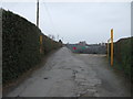
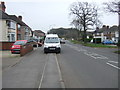
Road to allotments, Stockingford
Off Ansley Road (B4112).
Image: © JThomas
Taken: 11 Mar 2017
0.06 miles
2
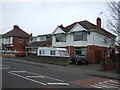
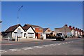
Houses on Ansley Road (B4112), Stockingford
Image: © JThomas
Taken: 11 Mar 2017
0.08 miles
3
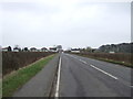
Ansley Road (B4112), Stockingford
Looking west.
Image: © JThomas
Taken: 11 Mar 2017
0.10 miles
4
Ansley Road (B4112), Stockingford
Looking east.
Image: © JThomas
Taken: 11 Mar 2017
0.12 miles
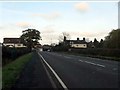
6
Astley Lane meeting the B4112 Ansley Road and the B4102 Arbury Road at Stockingford
This photo is looking along the Arbury Road from the junction, Ansley Road is to the left.
Image: © Mick Malpass
Taken: 1 Apr 2012
0.18 miles
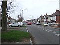
7
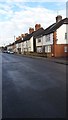
Church Road Stockingford
The densely packed housing stock on Church Road is typical of this area.
Image: © Peter Mackenzie
Taken: 24 Jan 2017
0.23 miles