IMAGES TAKEN NEAR TO
Tomkinson Road, NUNEATON, CV10 8BH
Introduction
This page details the photographs taken nearby to Tomkinson Road, CV10 8BH by members of the Geograph project.
The Geograph project started in 2005 with the aim of publishing, organising and preserving representative images for every square kilometre of Great Britain, Ireland and the Isle of Man.

There are currently over 7.5m images from over14,400 individuals and you can help contribute to the project by visiting https://www.geograph.org.uk
Image Map
Images are licensed for reuse under creativecommons.org/licenses/by-sa/2.0
Notes
- Clicking on the map will re-center to the selected point.
- The higher the marker number, the further away the image location is from the centre of the postcode.
Image Listing (57 Images Found)
Images are licensed for reuse under creativecommons.org/licenses/by-sa/2.0
Image
Details
Distance
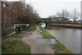
1
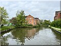
Housing near Wash Lane Bridge
On the Coventry Canal.
Image: © Andrew Abbott
Taken: 2 May 2023
0.02 miles

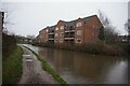
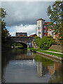
4
Canalside apartments near Nuneaton in Warwickshire
Looking south-east.
The apartment block is off Tomkinson Road near Wash Lane Bridge, No 21.
Jo Turner writes:
Image: © Roger D Kidd
Taken: 19 Aug 2013
0.03 miles
5
Canalside apartments near Nuneaton in Warwickshire
Looking south-east.
The apartment block is off Tomkinson Road near Wash Lane Bridge, No 21.
Jo Turner writes:
Image: © Roger D Kidd
Taken: 19 Aug 2013
0.03 miles
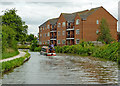
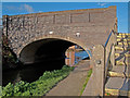
6
Coventry Canal at Wash Lane Bridge, bridge #21
Image: © Ian S
Taken: 6 Jan 2022
0.05 miles
7
Coventry Canal at Wash Lane Bridge, bridge #21
Image: © Ian S
Taken: 6 Jan 2022
0.05 miles
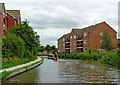
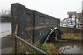
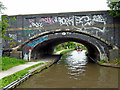
8
Wash Lane Bridge over the Coventry Canal, Nuneaton
Wash Lane Bridge, carries the B4102 over the Coventry Canal to the east of Nuneaton Town Centre; it's designated number is 21 and an iron plate above the centre of the bridge arch carries that number.
Image: © Trevor Littlewood
Taken: 11 Nov 2007
0.05 miles
9
Coventry Canal at Wash Lane Bridge in Nuneaton, Warwickshire
Wash Lane Bridge is No 21 across the Coventry Canal in Nuneaton, and does not carry Wash Lane (any more). The B4102 Croft Lane/Queens Road crosses the canal here.
Wash Lane Farm stood three hundred metres to the north of the bridge, the site now being occupied by the Manor Park Community School and Specialist Arts College. The road to it before recent major land development eliminated it was Wash Lane. The new road is an addition to Queens Road, leading to the town centre.
Image: © Roger Kidd
Taken: 25 Sep 2016
0.05 miles
10
Wash Lane Bridge in Nuneaton, Warwickshire
Wash Lane Bridge is No 24 across the Coventry Canal. It carries the B4102, renamed Queens Road, or an extended Croft Road - maps don't seem to know.
What a pity the local "sub-intelligentsia" think it is "cool" to paint scribble all over the bridge. Idiots.
Image: © Roger D Kidd
Taken: 19 Aug 2013
0.05 miles