IMAGES TAKEN NEAR TO
Atholl Crescent, NUNEATON, CV10 7PB
Introduction
This page details the photographs taken nearby to Atholl Crescent, CV10 7PB by members of the Geograph project.
The Geograph project started in 2005 with the aim of publishing, organising and preserving representative images for every square kilometre of Great Britain, Ireland and the Isle of Man.

There are currently over 7.5m images from over14,400 individuals and you can help contribute to the project by visiting https://www.geograph.org.uk
Image Map
Images are licensed for reuse under creativecommons.org/licenses/by-sa/2.0
Notes
- Clicking on the map will re-center to the selected point.
- The higher the marker number, the further away the image location is from the centre of the postcode.
Image Listing (11 Images Found)
Images are licensed for reuse under creativecommons.org/licenses/by-sa/2.0
Image
Details
Distance
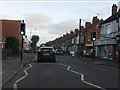
3
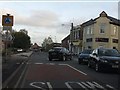
Arbury Road roundabout
Traffic queues for around one hundred yards on the opposite side of the road waiting for a bus which is blocking the road while loading a passenger.
Image: © Peter Whatley
Taken: 12 Nov 2011
0.15 miles
4
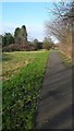
Path through the park
The park in Heath End, Nuneaton provides necessary recreational space in what is otherwise a large suburban area.
Image: © Peter Mackenzie
Taken: 24 Jan 2017
0.15 miles
5
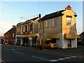
Buildings at junction of Croft Road & Heath End Road, Nuneaton
Croft Road can be seen in the foreground, Heath End Road at the right hand side of the picture. The building at the corner has clearly been much modernised, but still retains its distinctive curving Dutch gable topped with a little pediment. To its left is a former Co-op building, identifiable by the letters NCS, standing for Nuneaton Co-operative Society. It has very distinctive beige-coloured terracotta tiles, some with vertical banding, giving it a jazzy, art deco appearance. Easyfit, suppliers of bedroom furniture, now occupy both buildings.
Image: © A J Paxton
Taken: 15 Sep 2021
0.16 miles
6
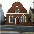
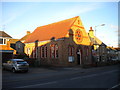
Stockingford Congregational Church, Nuneaton
This church on Croft Road was founded in 1907; see its page on the Congregational Federation website here https://www.congregational.org.uk/find-a-church/church-finder/120/stockingford . Congregational churches grew out of the Independents of the 17th century Puritan movement, each local congregation being independent and choosing its own pastor. In time they formed a Congregational Union and then a Congregational Church, which in 1972 joined with the Presbyterian Church of England to form the United Reformed Church https://en.wikipedia.org/wiki/Congregational_Union_of_England_and_Wales . Some however, chose to remain independent, as this congregation clearly did.
Image: © A J Paxton
Taken: 15 Sep 2021
0.18 miles
9
Stockingford Methodist Church
With the low winter Sun highlighting its attractiveness, Stockingford Methodist Church, on Arbury Road, is a relatively small and apparently quite early example of Methodist architecture.
Image: © Richard Vince
Taken: 2 Feb 2013
0.21 miles
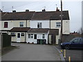
10
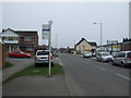
Bus stop on Heath End Road (B4112)
Looking east.
Image: © JThomas
Taken: 11 Mar 2017
0.23 miles