IMAGES TAKEN NEAR TO
Silver Walk, NUNEATON, CV10 7LY
Introduction
This page details the photographs taken nearby to Silver Walk, CV10 7LY by members of the Geograph project.
The Geograph project started in 2005 with the aim of publishing, organising and preserving representative images for every square kilometre of Great Britain, Ireland and the Isle of Man.

There are currently over 7.5m images from over14,400 individuals and you can help contribute to the project by visiting https://www.geograph.org.uk
Image Map
Images are licensed for reuse under creativecommons.org/licenses/by-sa/2.0
Notes
- Clicking on the map will re-center to the selected point.
- The higher the marker number, the further away the image location is from the centre of the postcode.
Image Listing (15 Images Found)
Images are licensed for reuse under creativecommons.org/licenses/by-sa/2.0
Image
Details
Distance
2
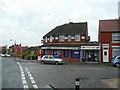
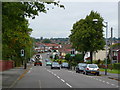
Off-licence, Granby Road, Nuneaton
At the junction with Tomkinson Road.
Image: © Jonathan Billinger
Taken: 4 Sep 2008
0.21 miles
3
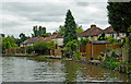
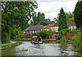
Coventry Canal in Nuneaton, Warwickshire
The housing by the Coventry Canal here is in Greenmore Road.
Image: © Roger D Kidd
Taken: 19 Aug 2013
0.22 miles
5
Coventry Canal in Nuneaton, Warwickshire
The housing by the Coventry Canal here is in Greenmore Road.
Image: © Roger D Kidd
Taken: 19 Aug 2013
0.22 miles
6
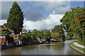
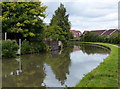
Coventry Canal in Nuneaton, Warwickshire
Looking north-west as the canal meanders through the suburbs of Nuneaton, and on towards Atherstone. The gardens and housing on the left are in Greenmoor Road.
Image: © Roger Kidd
Taken: 25 Sep 2016
0.22 miles
7
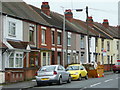
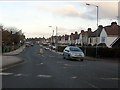
Terraced housing, Tomkinson Road, Nuneaton
Interwar housing on the west side of the town.
Unusual to find a terrace on a curving street - blocks of 4 and 6 houses are built in a straight line, with a change of angle only between each block. This can be seen from the slight change in roofline.
Image: © Jonathan Billinger
Taken: 4 Sep 2008
0.22 miles
9
Greenmoor Road, Nuneaton
A suburban road to the west of the town centre.
Image: © Jonathan Billinger
Taken: 4 Sep 2008
0.23 miles
10
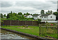
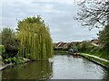
Back garden and allotments, Nuneaton, Warwickshire
This is by the Coventry Canal. The houses are in Greenmoor Road.
Image: © Roger D Kidd
Taken: 19 Aug 2013
0.23 miles