IMAGES TAKEN NEAR TO
Griff Way, NUNEATON, CV10 7DA
Introduction
This page details the photographs taken nearby to Griff Way, CV10 7DA by members of the Geograph project.
The Geograph project started in 2005 with the aim of publishing, organising and preserving representative images for every square kilometre of Great Britain, Ireland and the Isle of Man.

There are currently over 7.5m images from over14,400 individuals and you can help contribute to the project by visiting https://www.geograph.org.uk
Image Map
Images are licensed for reuse under creativecommons.org/licenses/by-sa/2.0
Notes
- Clicking on the map will re-center to the selected point.
- The higher the marker number, the further away the image location is from the centre of the postcode.
Image Listing (5 Images Found)
Images are licensed for reuse under creativecommons.org/licenses/by-sa/2.0
Image
Details
Distance
1
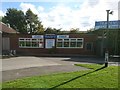
Tracey's Diner
Not as well advertised as some roadside restaurants. You would drive by and miss it very easily if you didn't know it was here.
Image: © Ian Paterson
Taken: 28 Sep 2017
0.00 miles
2
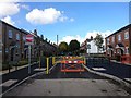
New meets old
But not for vehicular access it seems. Traffic restriction measures in Bermuda Village.
Image: © Ian Paterson
Taken: 28 Sep 2017
0.14 miles
3
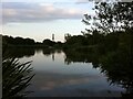
View across Bermuda Balancing Lake towards Bermuda Village
This pool on the Griff Brook was dug to hold run-off water from the nearby business park and prevent flooding. Bermuda Village nearby was built in 1893 to house miners working at the new Griff Clara colliery. Like Newdigate Colliery in Bedworth, the village drew its name from the local landowners at Arbury Hall, one of whom had recently served as governor of Bermuda. https://web.archive.org/web/20070310154326/http://www.nuneaton-online.org.uk/nuneaton/bermuda.htm
Image: © A J Paxton
Taken: 26 Jul 2021
0.16 miles
4
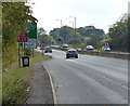
The A444 near the Bermuda Business Park
Image: © Mat Fascione
Taken: 28 Sep 2014
0.18 miles
5
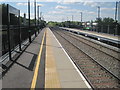
Bermuda Park railway station, Warwickshire
Opened in January 2016 by Network Rail on the line from Coventry to Nuneaton.
View south towards Bedworth and Coventry. Local stations on the line had closed in 1965, but this station was constructed on an entirely new site.
Image: © Nigel Thompson
Taken: 24 May 2016
0.19 miles