IMAGES TAKEN NEAR TO
Mancetter Road, NUNEATON, CV10 0HP
Introduction
This page details the photographs taken nearby to Mancetter Road, CV10 0HP by members of the Geograph project.
The Geograph project started in 2005 with the aim of publishing, organising and preserving representative images for every square kilometre of Great Britain, Ireland and the Isle of Man.

There are currently over 7.5m images from over14,400 individuals and you can help contribute to the project by visiting https://www.geograph.org.uk
Image Map
Images are licensed for reuse under creativecommons.org/licenses/by-sa/2.0
Notes
- Clicking on the map will re-center to the selected point.
- The higher the marker number, the further away the image location is from the centre of the postcode.
Image Listing (3 Images Found)
Images are licensed for reuse under creativecommons.org/licenses/by-sa/2.0
Image
Details
Distance
1
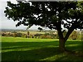
The Anker Valley
View across the valley of the River Anker from the outskirts of Nuneaton. The West Coast Main Line railway and the Coventry Canal run through the valley at this point. The Anker flows into the River Tame at Tamworth which is in turn a tributary of the Trent.
Image: © Stephen McKay
Taken: 30 Sep 2006
0.17 miles
2
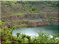
Hartshill Quarry
This huge flooded pit, to the east of Hartshill, was a granite quarry.
Image: © Stephen McKay
Taken: 30 Sep 2006
0.22 miles
3
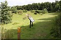
Oasis on the Quarryman's Walk Hartshill
The Quarryman's Walk passes through a community nature reserve at Caldecote Hill.
Image: © Richard Kay
Taken: 20 Jul 2008
0.24 miles