IMAGES TAKEN NEAR TO
Sanger Close, MARGATE, CT9 5TT
Introduction
This page details the photographs taken nearby to Sanger Close, CT9 5TT by members of the Geograph project.
The Geograph project started in 2005 with the aim of publishing, organising and preserving representative images for every square kilometre of Great Britain, Ireland and the Isle of Man.

There are currently over 7.5m images from over14,400 individuals and you can help contribute to the project by visiting https://www.geograph.org.uk
Image Map
Images are licensed for reuse under creativecommons.org/licenses/by-sa/2.0
Notes
- Clicking on the map will re-center to the selected point.
- The higher the marker number, the further away the image location is from the centre of the postcode.
Image Listing (48 Images Found)
Images are licensed for reuse under creativecommons.org/licenses/by-sa/2.0
Image
Details
Distance
1
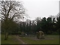
Playground, Tivoli Road, Margate
This small playground and climbing rock is in a small green with a path leading to Tivoli Park Road.
Image: © David Anstiss
Taken: 23 Mar 2013
0.04 miles
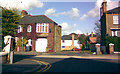
2
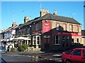
The Princess of Wales Pub, Margate
On junction of 20 Tivoli Road and Buckingham Road (on right).
Image: © David Anstiss
Taken: 17 Jan 2009
0.07 miles
3
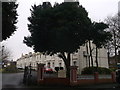
Alexandra Homes, South Range, Margate
Two ranges (of Grade II listed houses) facing each other across a green.
Founded in 1865, to commemorate the safe arrival in Margate of Her Royal Highness Princess Alexandra of Denmark, (who later became Queen Alexandra).
As seen from Tivoli Road.
See http://www.britishlistedbuildings.co.uk/en-356686-alexandra-homes-kent for more details about the listed ranges.
Image: © David Anstiss
Taken: 23 Mar 2013
0.08 miles

5
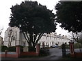
Alexandra Homes, North Range, Margate
Two ranges (of Grade II listed houses) facing each other across a green.
Founded in 1865, to commemorate the safe arrival in Margate of Her Royal Highness Princess Alexandra of Denmark, (who later became Queen Alexandra).
As seen from Tivoli Road.
See http://www.britishlistedbuildings.co.uk/en-356686-alexandra-homes-kent for more details about the listed ranges.
Image: © David Anstiss
Taken: 23 Mar 2013
0.08 miles
6

Princess of Wales
A Shepherd Neame pub on Tivoli Road at the junction with Buckingham Road.
Image: © Oast House Archive
Taken: 26 Jul 2014
0.10 miles
7

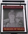
Princess of Wales sign
Sign for Image], a Shepherd Neame pub on Tivoli Road at the junction with Buckingham Road.
Image: © Oast House Archive
Taken: 26 Jul 2014
0.10 miles
8
Princess of Wales Pub Sign, Margate
Outside Image on Tivoli Road.
Image: © David Anstiss
Taken: 23 Mar 2013
0.10 miles
9
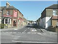
Helena Avenue, off Beatrice Road, Margate
Helena Avenue looks to be a fairly recently constructed road, as the tarmac still looks fresh and there is a new-looking house just off the road. I find this rather unusual, as the road looks too narrow to be an avenue, especially because it passes between two houses and the houses are located perpendicular to the road. I think perhaps Helena Lane or Helena Mews might have been more appropriate, but there you go! View taken looking northwest towards Margate. Here you are virtually looking out of the square into square TR3570, the top edge of TR3569 being just before the house you see in the background.
Image: © Robert Lamb
Taken: 27 Oct 2008
0.11 miles
10
Buckingham Road, Margate
As seen from Tivoli Road. with the Princess of Wales public house on the corner.
Image: © John Baker
Taken: 5 Sep 2012
0.11 miles