IMAGES TAKEN NEAR TO
Royal Esplanade, MARGATE, CT9 5EN
Introduction
This page details the photographs taken nearby to Royal Esplanade, CT9 5EN by members of the Geograph project.
The Geograph project started in 2005 with the aim of publishing, organising and preserving representative images for every square kilometre of Great Britain, Ireland and the Isle of Man.

There are currently over 7.5m images from over14,400 individuals and you can help contribute to the project by visiting https://www.geograph.org.uk
Image Map (Loading...)


Getting Data...Please wait
Leaflet Map data © OpenStreetMap
Images are licensed for reuse under creativecommons.org/licenses/by-sa/2.0
Notes
- Clicking on the map will re-center to the selected point.
- The higher the marker number, the further away the image location is from the centre of the postcode.
Image Listing (35 Images Found)
Images are licensed for reuse under creativecommons.org/licenses/by-sa/2.0
Image
Details
Distance
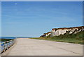
4
Don't get too Close, Jack !!
On promenade looking west across Westbrook Bay.
Image: © David Anstiss
Taken: 21 Mar 2008
0.08 miles
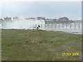
5
Sunken Garden, Westbrook
The only reference I can find says this was established in the 1930s
Image: © Keith Edkins
Taken: 21 Jun 2015
0.09 miles
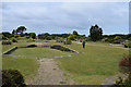
7
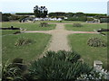
The Sunken Garden
This is a feature between the Royal Esplanade at Westbrook and the clifftop. The sea to the north is visible. Unfortunately a Bath Parade Gardens it ain't!
Image: © Jonathan Billinger
Taken: 25 Apr 2007
0.11 miles