IMAGES TAKEN NEAR TO
Westonville Avenue, MARGATE, CT9 5DY
Introduction
This page details the photographs taken nearby to Westonville Avenue, CT9 5DY by members of the Geograph project.
The Geograph project started in 2005 with the aim of publishing, organising and preserving representative images for every square kilometre of Great Britain, Ireland and the Isle of Man.

There are currently over 7.5m images from over14,400 individuals and you can help contribute to the project by visiting https://www.geograph.org.uk
Image Map
Images are licensed for reuse under creativecommons.org/licenses/by-sa/2.0
Notes
- Clicking on the map will re-center to the selected point.
- The higher the marker number, the further away the image location is from the centre of the postcode.
Image Listing (42 Images Found)
Images are licensed for reuse under creativecommons.org/licenses/by-sa/2.0
Image
Details
Distance


7
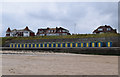
21 beach huts and a beach hut
One of life's little mysteries - why is there a gap in such an otherwise uniform row? Just to annoy those with OCD...
Image: © Keith Edkins
Taken: 21 Jun 2015
0.11 miles
8
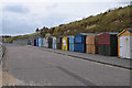
Beach huts, Westbrook Bay
I wonder whether there is some ownership difference between the varied ones at this end and the uniform ones in the distance - perhaps those are affordable beach huts?
Image: © Keith Edkins
Taken: 21 Jun 2015
0.11 miles
9
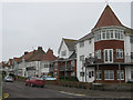
Westcliff Gardens
Seen from Royal Esplanade
Image: © Paul Harrop
Taken: 2 Jun 2016
0.11 miles
