IMAGES TAKEN NEAR TO
Hatfeild Road, MARGATE, CT9 5AT
Introduction
This page details the photographs taken nearby to Hatfeild Road, CT9 5AT by members of the Geograph project.
The Geograph project started in 2005 with the aim of publishing, organising and preserving representative images for every square kilometre of Great Britain, Ireland and the Isle of Man.

There are currently over 7.5m images from over14,400 individuals and you can help contribute to the project by visiting https://www.geograph.org.uk
Image Map
Images are licensed for reuse under creativecommons.org/licenses/by-sa/2.0
Notes
- Clicking on the map will re-center to the selected point.
- The higher the marker number, the further away the image location is from the centre of the postcode.
Image Listing (170 Images Found)
Images are licensed for reuse under creativecommons.org/licenses/by-sa/2.0
Image
Details
Distance
1

Midsummer sunset, Margate
Less than 4 hours after astronomical solstice. The direction of sunset is 4° west of northwest.
Image: © Keith Edkins
Taken: 21 Jun 2015
0.01 miles
2

Thanet : Thanet Scenery
Looking down to Kent with towns including Margate and Ramsgate in view.
Image: © Lewis Clarke
Taken: 18 Jun 2017
0.01 miles
4
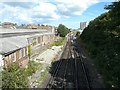
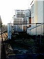
View from Hartsdown Road bridge
Of the railway lines as they approach Margate station. Arlington House rears up centre-right, while on the left is the disused building of Precious and Base Metal Components Ltd who appear to have closed their Margate depot but are still trading elsewhere in the UK http://www.p-and-b.com/about_us/about.html
Image: © John Baker
Taken: 8 Sep 2013
0.04 miles
6

Hatfeild Road, Margate
The horse's head is one of several adorning the top of a wall at the junction with Canterbury Road.
Image: © Paul Harrop
Taken: 2 Jun 2016
0.04 miles
9
22-26, Crescent Road
To the left of the derelict building, there is a public footpath which runs beside the railway line between Westbrook Road and Station Road.
Image: © John Baker
Taken: 9 Dec 2018
0.06 miles
10
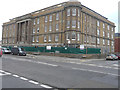
Ongoing alterations to 38, Canterbury Road
Planning permission has been granted by Thanet District Council under application number F/TH/11/0893 for the “change of use of nurses home to 29 flats with erection of 5 storey extension to allow alterations to internal layout to existing building”. The location was described a Former Nurses Home, Royal Sea Bathing Hospital.
Image: © John Baker
Taken: 6 Nov 2016
0.06 miles