IMAGES TAKEN NEAR TO
Royal Crescent, MARGATE, CT9 5AL
Introduction
This page details the photographs taken nearby to Royal Crescent, CT9 5AL by members of the Geograph project.
The Geograph project started in 2005 with the aim of publishing, organising and preserving representative images for every square kilometre of Great Britain, Ireland and the Isle of Man.

There are currently over 7.5m images from over14,400 individuals and you can help contribute to the project by visiting https://www.geograph.org.uk
Image Map (Loading...)


Getting Data...Please wait
Leaflet Map data © OpenStreetMap
Images are licensed for reuse under creativecommons.org/licenses/by-sa/2.0
Notes
- Clicking on the map will re-center to the selected point.
- The higher the marker number, the further away the image location is from the centre of the postcode.
Image Listing (183 Images Found)
Images are licensed for reuse under creativecommons.org/licenses/by-sa/2.0
Image
Details
Distance

6
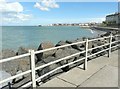
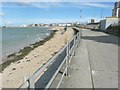
Looking east-northeast from Westbrook Promenade
Towards the seafront of Margate, in the distance.
Image: © John Baker
Taken: 8 Sep 2013
0.04 miles

8
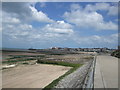
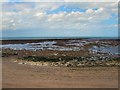
Beaches by Westbrook Promenade
Part of the Thanet Coastal Path
Image: © Paul Gillett
Taken: 29 Jun 2012
0.05 miles
10
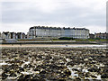
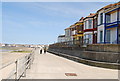
Royal Crescent, Margate
The left-hand end in the Nayland Rock Hotel, and the foreground is part of Nayland Rock, a platform of chalk extending some way out to sea at low tide.
Image: © Robin Webster
Taken: 20 Mar 2016
0.05 miles