IMAGES TAKEN NEAR TO
Manston Road, MARGATE, CT9 4LY
Introduction
This page details the photographs taken nearby to Manston Road, CT9 4LY by members of the Geograph project.
The Geograph project started in 2005 with the aim of publishing, organising and preserving representative images for every square kilometre of Great Britain, Ireland and the Isle of Man.

There are currently over 7.5m images from over14,400 individuals and you can help contribute to the project by visiting https://www.geograph.org.uk
Image Map
Images are licensed for reuse under creativecommons.org/licenses/by-sa/2.0
Notes
- Clicking on the map will re-center to the selected point.
- The higher the marker number, the further away the image location is from the centre of the postcode.
Image Listing (20 Images Found)
Images are licensed for reuse under creativecommons.org/licenses/by-sa/2.0
Image
Details
Distance
1
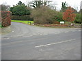
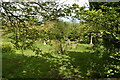
Entrance To Margate Crematorium
The entrance to Margate Crematorium from Manston Road.
Image: © David Mastin
Taken: 18 Feb 2007
0.05 miles
9
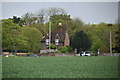
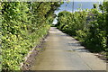
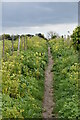
Footpath to Shottendane Road
A path leads from Manston Road towards the road (in a valley). Margate is in the background on the other side of the valley.
Image: © David Anstiss
Taken: 6 Feb 2011
0.18 miles