IMAGES TAKEN NEAR TO
Bayer Street, CT9 4GN
Introduction
This page details the photographs taken nearby to Bayer Street, CT9 4GN by members of the Geograph project.
The Geograph project started in 2005 with the aim of publishing, organising and preserving representative images for every square kilometre of Great Britain, Ireland and the Isle of Man.

There are currently over 7.5m images from over14,400 individuals and you can help contribute to the project by visiting https://www.geograph.org.uk
Image Map
Images are licensed for reuse under creativecommons.org/licenses/by-sa/2.0
Notes
- Clicking on the map will re-center to the selected point.
- The higher the marker number, the further away the image location is from the centre of the postcode.
Image Listing (19 Images Found)
Images are licensed for reuse under creativecommons.org/licenses/by-sa/2.0
Image
Details
Distance
1
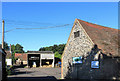
Yard at Nash Farm
And entrance to Nash Farm Shop. Old farm buildings still hanging on while new stuff springs up all around.
Image: © Des Blenkinsopp
Taken: 11 Aug 2018
0.06 miles
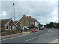
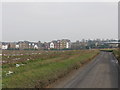
2
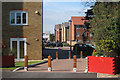
New Housing off Nash Road
Completed in the last few years.
Image: © Oast House Archive
Taken: 21 Sep 2010
0.09 miles
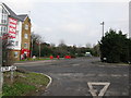
4
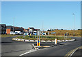
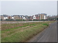
Nash Road and Star Lane Roundabout
For the moment, these two roads are on the boundary of the extensive new urban development around here.
Image: © Des Blenkinsopp
Taken: 11 Aug 2018
0.12 miles
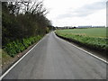
5
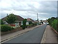
View along unnamed road in direction of Nash Road
Image: © Nick Smith
Taken: 12 Jan 2010
0.13 miles