IMAGES TAKEN NEAR TO
Star Lane, MARGATE, CT9 4FZ
Introduction
This page details the photographs taken nearby to Star Lane, CT9 4FZ by members of the Geograph project.
The Geograph project started in 2005 with the aim of publishing, organising and preserving representative images for every square kilometre of Great Britain, Ireland and the Isle of Man.

There are currently over 7.5m images from over14,400 individuals and you can help contribute to the project by visiting https://www.geograph.org.uk
Image Map
Images are licensed for reuse under creativecommons.org/licenses/by-sa/2.0
Notes
- Clicking on the map will re-center to the selected point.
- The higher the marker number, the further away the image location is from the centre of the postcode.
Image Listing (35 Images Found)
Images are licensed for reuse under creativecommons.org/licenses/by-sa/2.0
Image
Details
Distance
1

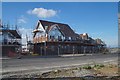
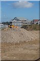
Cross Quays development
The Persimmon Homes 'Cross Quays development at Westwood.
This is the first phase of the development, which includes 'affordable homes', and is due to be completed in Spring 2014. As part of the development, Manston Court Road has been sealed off at the junction with Haine Road.
Taken at the junction of Star Lane and Manston Court Road on 7th October 2013.
Image: © smellfungus
Taken: 7 Oct 2013
0.04 miles
2
Cross Quays housing development at Westwood
The Persimmon Homes 'Cross Quays development at Westwood.
This is the first phase of the development. The house is the centre is likely to be the show home.
Image: © smellfungus
Taken: 7 Oct 2013
0.04 miles
3
Cross Quays development in Westwood, Kent
The Persimmon Homes 'Cross Quays development at Westwood.
Image: © smellfungus
Taken: 7 Oct 2013
0.04 miles
4
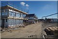
New housing along Manston Court Road
Planning permission has been granted by Thanet District Council under application number R/TH/11/0094 for an “application for the approval of access, appearance, landscaping, layout and scale pursuant to condition 1 of OL/TH/06/0650 for part of Phase 1 and part of Phase 2 of a mixed use urban extension comprising; residential use (Class C3), community facilities (Class D1), commercial and employment uses (Class A1-A5, B1 and D2) and associated infrastructure including a new link road, associated alterations to existing junctions and new access arrangements”. The location was described as land north of Haine Road Broadstairs and west of Nash Road, Margate.
Image: © John Baker
Taken: 22 Jun 2014
0.04 miles
6
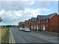
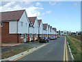
Cross Quays Development, Westwood, Kent
The Persimmon Homes 'Cross Quays development at Westwood.
This is the first phase of the development; the houses to the left are plots 30 - 37.
Taken at the junction of Star Lane and Manston Court Road on 7th October 2013.
Image: © smellfungus
Taken: 7 Oct 2013
0.04 miles
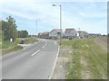
10

New housing estate in Westwood
Started around 2016
Image: © David Howard
Taken: 30 Jun 2018
0.10 miles