IMAGES TAKEN NEAR TO
Ramsgate Road, MARGATE, CT9 4BF
Introduction
This page details the photographs taken nearby to Ramsgate Road, CT9 4BF by members of the Geograph project.
The Geograph project started in 2005 with the aim of publishing, organising and preserving representative images for every square kilometre of Great Britain, Ireland and the Isle of Man.

There are currently over 7.5m images from over14,400 individuals and you can help contribute to the project by visiting https://www.geograph.org.uk
Image Map
Images are licensed for reuse under creativecommons.org/licenses/by-sa/2.0
Notes
- Clicking on the map will re-center to the selected point.
- The higher the marker number, the further away the image location is from the centre of the postcode.
Image Listing (24 Images Found)
Images are licensed for reuse under creativecommons.org/licenses/by-sa/2.0
Image
Details
Distance
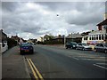
1
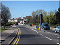
Junction on Ramsgate Road
Heading North into Margate.
Image: © Oast House Archive
Taken: 23 Apr 2010
0.03 miles
2
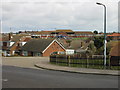
Houses on Rowe Close and the QEQM hospital
The long building is the Queen Elizabeth The Queen Mother (QEQM) hospital on the A254 Ramsgate Road.
Image: © Nick Smith
Taken: 24 Mar 2008
0.06 miles
3
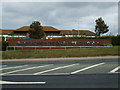
QEQM Hospital, Margate
Queen Elizabeth The Queen Mother Hospital, Margate. The name that's nearly as big as the hospital.
Image: © Phillip Perry
Taken: 2 Oct 2008
0.08 miles
4
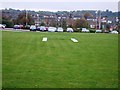
H is for?
Either hospital or helipad, well as it's inside a hospital (The Queen Elizabeth Queen Mother hospital) it must be for a helipad. The square is certainly big enough for a helicopter to land in the middle of the grounds.
Image: © Phillip Perry
Taken: 15 Oct 2008
0.09 miles
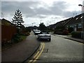
5
Ramsgate Road, Margate
The A254 that runs between Margate and Ramsgate.
Image: © Phillip Perry
Taken: 2 Oct 2008
0.10 miles
7
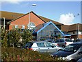
QEQM Hospital II, Margate
It looks like either a Travelodge or Tesco, but it's a clean modern hospital building opened in June 1996.
Image: © Phillip Perry
Taken: 2 Oct 2008
0.11 miles
8
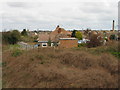
Houses on Nash Court Gardens and Road
Viewed from the bridge over the dismantled railway line.
Image: © Nick Smith
Taken: 24 Mar 2008
0.13 miles
9
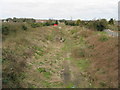
Looking NW along dismantled railway line near Nash Road
Image: © Nick Smith
Taken: 24 Mar 2008
0.16 miles
10
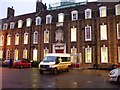
QEQM Hospital III, Margate
This is the St. Peter's Road entrance, in a previous life it was called Margate General Hospital, the stone above the door dates it to 1930, before that it was Margate Cottage Hospital from about 1876.
Image: © Phillip Perry
Taken: 26 Nov 2008
0.18 miles