IMAGES TAKEN NEAR TO
St. Peters Road, MARGATE, CT9 4AQ
Introduction
This page details the photographs taken nearby to St. Peters Road, CT9 4AQ by members of the Geograph project.
The Geograph project started in 2005 with the aim of publishing, organising and preserving representative images for every square kilometre of Great Britain, Ireland and the Isle of Man.

There are currently over 7.5m images from over14,400 individuals and you can help contribute to the project by visiting https://www.geograph.org.uk
Image Map
Images are licensed for reuse under creativecommons.org/licenses/by-sa/2.0
Notes
- Clicking on the map will re-center to the selected point.
- The higher the marker number, the further away the image location is from the centre of the postcode.
Image Listing (15 Images Found)
Images are licensed for reuse under creativecommons.org/licenses/by-sa/2.0
Image
Details
Distance
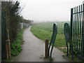
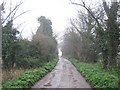
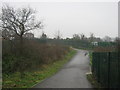
2
Footpath to St. Peter's Footpath
A track leads from the A254 St.Peter's Road towards a footpath between Margate and St.Peter's.
Image: © David Anstiss
Taken: 20 Feb 2011
0.04 miles
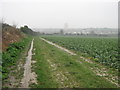
3
Field by St. Peter's Road, Margate
You can see the land flatten out near the coast
Image: © David Howard
Taken: 30 Jun 2018
0.05 miles
4
St. Peter's Footpath to Broadstairs
This path leads from College Road, Margate (beside the railway, on the left) towards Broadstairs.
It is part of the Turner and Dickens Walk to Broadstairs.
Another footpath leads right towards St.Peter's Road.
Image: © David Anstiss
Taken: 20 Feb 2011
0.09 miles
5
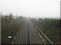
Railway to Broadstairs
As seen from Image
This line leads from Margate to Broadstairs.
Image: © David Anstiss
Taken: 20 Feb 2011
0.13 miles
6
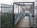
Footbridge on St. Peter's Footpath
This bridge leads over the railway (between Broadstairs and Margate).
It is also used by the Turner and Dickens walk between Broadstairs and Margate.
Image: © David Anstiss
Taken: 20 Feb 2011
0.13 miles
7
Track to St. Peter's Road
This track (and bridleway) leads from Ramsgate Road towards Updown Farm and Updown House.
Image: © David Anstiss
Taken: 20 Feb 2011
0.15 miles
8

Railway to Margate
As seen from Image
This line leads from Broadstairs to Margate.
Image: © David Anstiss
Taken: 20 Feb 2011
0.16 miles
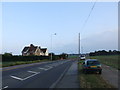
9
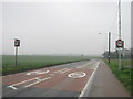
A255 St.Peter's Road
This road leads from Margate to Broadstairs.
Image: © David Anstiss
Taken: 20 Feb 2011
0.17 miles
10
St. Peter's Footpath towards Margate
This path leads from Broadstairs to Margate, it leads towards College Road.
It is also used by the Turner and Dickens Walk to Margate.
Image: © David Anstiss
Taken: 20 Feb 2011
0.18 miles