IMAGES TAKEN NEAR TO
Dane Valley Road, MARGATE, CT9 3XY
Introduction
This page details the photographs taken nearby to Dane Valley Road, CT9 3XY by members of the Geograph project.
The Geograph project started in 2005 with the aim of publishing, organising and preserving representative images for every square kilometre of Great Britain, Ireland and the Isle of Man.

There are currently over 7.5m images from over14,400 individuals and you can help contribute to the project by visiting https://www.geograph.org.uk
Image Map
Images are licensed for reuse under creativecommons.org/licenses/by-sa/2.0
Notes
- Clicking on the map will re-center to the selected point.
- The higher the marker number, the further away the image location is from the centre of the postcode.
Image Listing (11 Images Found)
Images are licensed for reuse under creativecommons.org/licenses/by-sa/2.0
Image
Details
Distance
1
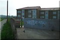
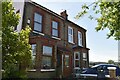
Flats on Tomlin Drive
Taken at the back of the estate from a track named Broadley Road.
Image: © Thomas Grant
Taken: 7 Jun 2007
0.13 miles
2
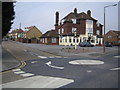
Margate: The Dane Valley Public House
Public house serving the Dane Valley housing estate, at the junction of Arlington Gardens up the hill to the left and Dane Valley Road across the mini-roundabout.
Image: © Nigel Cox
Taken: 7 Jun 2007
0.14 miles
3
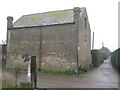
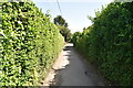
Barn beside St. Peter's Footpath
Barn close to Callis Grange.
St.Peter's Footpath becomes a bridleway after this point.
It is used by the Turner and Dickens Walk towards Broadstairs.
Image: © David Anstiss
Taken: 20 Feb 2011
0.18 miles
5
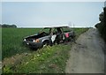
Burnt-out car
Abandoned wreck on Dane Valley Road. It had a notice stuck to it informing the owner to remove it or face prosecution. I don't think the owner left it there.
Image: © Thomas Grant
Taken: 7 Jun 2007
0.19 miles
6
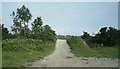
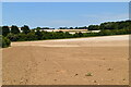
"Anglo-Saxon Burial Ground"
Not a terribly interesting picture, but an interesting spot. On the OS 1:25000 maps, this area is marked as an "Anglo-Saxon Burial Ground". It's not been looked after, and is now used by fly tippers and BMX riders. It's hard to tell if the bike jumps (one pictured here) are ancient barrows or have been piled up more recently, but the whole thing is rather sad. I suppose Saxon stuff is ten a penny in/on Thanet!
Image: © Thomas Grant
Taken: 7 Jun 2007
0.19 miles
10
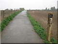
St. Peter's Footpath to Broadstairs
This path leads from College Road, Margate (beside the railway, on the left) towards Broadstairs.
It is part of the Turner and Dickens Walk to Broadstairs.
The section along St.Peter's Footpath has been marked by posts (A - F)
A lot have been vandalised.
Image: © David Anstiss
Taken: 20 Feb 2011
0.21 miles