IMAGES TAKEN NEAR TO
Palmer Crescent, MARGATE, CT9 3XN
Introduction
This page details the photographs taken nearby to Palmer Crescent, CT9 3XN by members of the Geograph project.
The Geograph project started in 2005 with the aim of publishing, organising and preserving representative images for every square kilometre of Great Britain, Ireland and the Isle of Man.

There are currently over 7.5m images from over14,400 individuals and you can help contribute to the project by visiting https://www.geograph.org.uk
Image Map
Images are licensed for reuse under creativecommons.org/licenses/by-sa/2.0
Notes
- Clicking on the map will re-center to the selected point.
- The higher the marker number, the further away the image location is from the centre of the postcode.
Image Listing (7 Images Found)
Images are licensed for reuse under creativecommons.org/licenses/by-sa/2.0
Image
Details
Distance
2
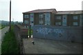
Flats on Tomlin Drive
Taken at the back of the estate from a track named Broadley Road.
Image: © Thomas Grant
Taken: 7 Jun 2007
0.19 miles
3
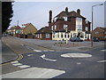
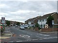
Margate: The Dane Valley Public House
Public house serving the Dane Valley housing estate, at the junction of Arlington Gardens up the hill to the left and Dane Valley Road across the mini-roundabout.
Image: © Nigel Cox
Taken: 7 Jun 2007
0.20 miles
6
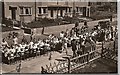
Selborne Road - Victory Street Party Sep 1, 1945
Looking from "even" numbered houses
Image: © Brian Attree
Taken: 1 Sep 1945
0.24 miles
