IMAGES TAKEN NEAR TO
Broadley Road, MARGATE, CT9 3UL
Introduction
This page details the photographs taken nearby to Broadley Road, CT9 3UL by members of the Geograph project.
The Geograph project started in 2005 with the aim of publishing, organising and preserving representative images for every square kilometre of Great Britain, Ireland and the Isle of Man.

There are currently over 7.5m images from over14,400 individuals and you can help contribute to the project by visiting https://www.geograph.org.uk
Image Map
Images are licensed for reuse under creativecommons.org/licenses/by-sa/2.0
Notes
- Clicking on the map will re-center to the selected point.
- The higher the marker number, the further away the image location is from the centre of the postcode.
Image Listing (32 Images Found)
Images are licensed for reuse under creativecommons.org/licenses/by-sa/2.0
Image
Details
Distance
2
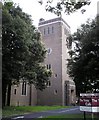
Holy Trinity Church, Northdown Park Road
Replacement built in 1958 as the old church was bombed in 1943.
Image: © Thomas Grant
Taken: 7 Jun 2007
0.07 miles
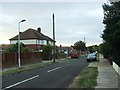
4
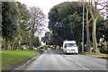
Northdown Park Road, B2051
Northdown Park is on the left.
Image: © Robin Webster
Taken: 8 Feb 2018
0.09 miles

6
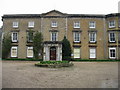
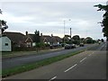
The front of Northdown House
The house was the country home of a notable local family but is now owned by Thanet District Council. The building is currently being restored to its former splendour.
Image: © Nick Smith
Taken: 22 Mar 2008
0.10 miles
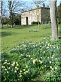
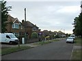
9
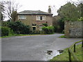
The Coach house on the road to Northdown House
Image: © Nick Smith
Taken: 22 Mar 2008
0.11 miles