IMAGES TAKEN NEAR TO
Dane Valley Road, MARGATE, CT9 3RU
Introduction
This page details the photographs taken nearby to Dane Valley Road, CT9 3RU by members of the Geograph project.
The Geograph project started in 2005 with the aim of publishing, organising and preserving representative images for every square kilometre of Great Britain, Ireland and the Isle of Man.

There are currently over 7.5m images from over14,400 individuals and you can help contribute to the project by visiting https://www.geograph.org.uk
Image Map
Images are licensed for reuse under creativecommons.org/licenses/by-sa/2.0
Notes
- Clicking on the map will re-center to the selected point.
- The higher the marker number, the further away the image location is from the centre of the postcode.
Image Listing (9 Images Found)
Images are licensed for reuse under creativecommons.org/licenses/by-sa/2.0
Image
Details
Distance
1
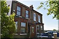
Margate: The Dane Valley Public House
Public house serving the Dane Valley housing estate, at the junction of Arlington Gardens up the hill to the left and Dane Valley Road across the mini-roundabout.
Image: © Nigel Cox
Taken: 7 Jun 2007
0.06 miles

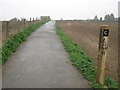
3

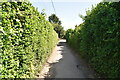
St. Peter's Footpath (2)
This path leads from College Road, Margate (beside the railway, on the left) towards Vicarage Street, Broadstairs.
It is part of the Turner and Dickens Walk to Broadstairs.
Image: © David Anstiss
Taken: 20 Feb 2011
0.15 miles
4
St. Peter's Footpath to Broadstairs
This path leads from College Road, Margate (beside the railway, on the left) towards Broadstairs.
It is part of the Turner and Dickens Walk to Broadstairs.
The section along St.Peter's Footpath has been marked by posts (A - F)
A lot have been vandalised.
Image: © David Anstiss
Taken: 20 Feb 2011
0.15 miles
5
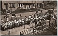
Selborne Road - Victory Street Party Sep 1, 1945
Looking from "even" numbered houses
Image: © Brian Attree
Taken: 1 Sep 1945
0.18 miles
6
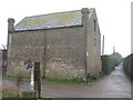
Barn beside St. Peter's Footpath
Barn close to Callis Grange.
St.Peter's Footpath becomes a bridleway after this point.
It is used by the Turner and Dickens Walk towards Broadstairs.
Image: © David Anstiss
Taken: 20 Feb 2011
0.19 miles
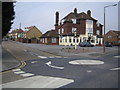
8
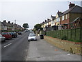
Cliftonville: Selborne Road
I think this is the same part of the road that Brian's Image was being held in, albeit not from the same bedroom window!
Postscript: Brian has confirmed that this is the same location. The gateway to the house with the square porch behind the van in Brian's image is the gateway next to the dustbins in this one.
Image: © Nigel Cox
Taken: 7 Jun 2007
0.22 miles