IMAGES TAKEN NEAR TO
Foreland Avenue, MARGATE, CT9 3NG
Introduction
This page details the photographs taken nearby to Foreland Avenue, CT9 3NG by members of the Geograph project.
The Geograph project started in 2005 with the aim of publishing, organising and preserving representative images for every square kilometre of Great Britain, Ireland and the Isle of Man.

There are currently over 7.5m images from over14,400 individuals and you can help contribute to the project by visiting https://www.geograph.org.uk
Image Map
Images are licensed for reuse under creativecommons.org/licenses/by-sa/2.0
Notes
- Clicking on the map will re-center to the selected point.
- The higher the marker number, the further away the image location is from the centre of the postcode.
Image Listing (23 Images Found)
Images are licensed for reuse under creativecommons.org/licenses/by-sa/2.0
Image
Details
Distance
7

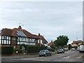
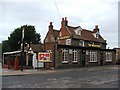
Cliftonville: The Wheatsheaf Public House
Behind the modern trappings and extensions this is an old flint-built public house, said to date in part from 1733. Victorian maps show it at the western end of the wooded hamlet of North Down, surrounded by fields. Having gone through a Whitbread / Beefeater phase, it is now owned by Greene King and is operated as one of their Hungry Horse restaurant outlets.
Image: © Nigel Cox
Taken: 7 Jun 2007
0.08 miles
10
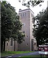
Holy Trinity Church, Northdown Park Road
Replacement built in 1958 as the old church was bombed in 1943.
Image: © Thomas Grant
Taken: 7 Jun 2007
0.13 miles