IMAGES TAKEN NEAR TO
Northdown Road, MARGATE, CT9 3LD
Introduction
This page details the photographs taken nearby to Northdown Road, CT9 3LD by members of the Geograph project.
The Geograph project started in 2005 with the aim of publishing, organising and preserving representative images for every square kilometre of Great Britain, Ireland and the Isle of Man.

There are currently over 7.5m images from over14,400 individuals and you can help contribute to the project by visiting https://www.geograph.org.uk
Image Map
Images are licensed for reuse under creativecommons.org/licenses/by-sa/2.0
Notes
- Clicking on the map will re-center to the selected point.
- The higher the marker number, the further away the image location is from the centre of the postcode.
Image Listing (14 Images Found)
Images are licensed for reuse under creativecommons.org/licenses/by-sa/2.0
Image
Details
Distance
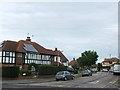
1
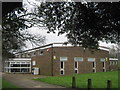
Cliftonville Library
On Queen Elizabeth Avenue, at its junction with Northdown Road and in a corner of Northdown Park.
Image: © David Anstiss
Taken: 20 Feb 2011
0.12 miles
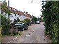
2
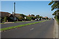
Queen Elizabeth Avenue, Cliftonville
This is a short stretch of dual carriageway through a mainly residential area.
Image: © Philip Halling
Taken: 5 Aug 2007
0.13 miles
5
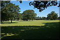
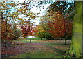
Northdown Park, Cliftonville
A cricket match on Northdown Park.
Image: © Philip Halling
Taken: 5 Aug 2007
0.21 miles
8
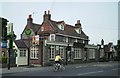
Flint cottage on Queen Elizabeth Avenue
Image: © Philip Halling
Taken: 5 Aug 2007
0.22 miles