IMAGES TAKEN NEAR TO
Sandhurst Road, MARGATE, CT9 3JQ
Introduction
This page details the photographs taken nearby to Sandhurst Road, CT9 3JQ by members of the Geograph project.
The Geograph project started in 2005 with the aim of publishing, organising and preserving representative images for every square kilometre of Great Britain, Ireland and the Isle of Man.

There are currently over 7.5m images from over14,400 individuals and you can help contribute to the project by visiting https://www.geograph.org.uk
Image Map
Images are licensed for reuse under creativecommons.org/licenses/by-sa/2.0
Notes
- Clicking on the map will re-center to the selected point.
- The higher the marker number, the further away the image location is from the centre of the postcode.
Image Listing (14 Images Found)
Images are licensed for reuse under creativecommons.org/licenses/by-sa/2.0
Image
Details
Distance
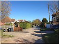
1
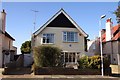
Blue plaque house in Percy Avenue
Frank Richards, the creator of Billy Bunter, lived here.
Image: © Steve Daniels
Taken: 12 Oct 2012
0.14 miles
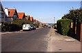
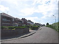
5
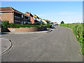
View along The Ridings
The last row of houses before the cliff edge ~100m away.
Image: © Nick Smith
Taken: 18 Oct 2008
0.20 miles