IMAGES TAKEN NEAR TO
Eastchurch Road, MARGATE, CT9 3HX
Introduction
This page details the photographs taken nearby to Eastchurch Road, CT9 3HX by members of the Geograph project.
The Geograph project started in 2005 with the aim of publishing, organising and preserving representative images for every square kilometre of Great Britain, Ireland and the Isle of Man.

There are currently over 7.5m images from over14,400 individuals and you can help contribute to the project by visiting https://www.geograph.org.uk
Image Map (Loading...)


Getting Data...Please wait
Leaflet Map data © OpenStreetMap
Images are licensed for reuse under creativecommons.org/licenses/by-sa/2.0
Notes
- Clicking on the map will re-center to the selected point.
- The higher the marker number, the further away the image location is from the centre of the postcode.
Image Listing (14 Images Found)
Images are licensed for reuse under creativecommons.org/licenses/by-sa/2.0
Image
Details
Distance
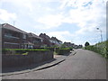
1
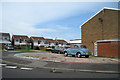
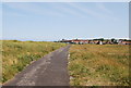
View along The Ridings
The last row of houses before the cliff edge ~100m away.
Image: © Nick Smith
Taken: 18 Oct 2008
0.13 miles
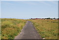
5
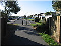
Path through to Monkton Gardens from The Ridings
Image: © Nick Smith
Taken: 18 Oct 2008
0.17 miles
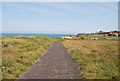
7
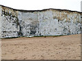
Cliff, Botany Bay
These cliffs erode in an unusual way for seaside chalk. They are fairly well protected by sand from direct sea erosion, so probably crack from freezing, flaking away in layers top downwards.
Image: © Robin Webster
Taken: 8 Feb 2018
0.20 miles