IMAGES TAKEN NEAR TO
St. Peters Footpath, MARGATE, CT9 2SP
Introduction
This page details the photographs taken nearby to St. Peters Footpath, CT9 2SP by members of the Geograph project.
The Geograph project started in 2005 with the aim of publishing, organising and preserving representative images for every square kilometre of Great Britain, Ireland and the Isle of Man.

There are currently over 7.5m images from over14,400 individuals and you can help contribute to the project by visiting https://www.geograph.org.uk
Image Map
Images are licensed for reuse under creativecommons.org/licenses/by-sa/2.0
Notes
- Clicking on the map will re-center to the selected point.
- The higher the marker number, the further away the image location is from the centre of the postcode.
Image Listing (35 Images Found)
Images are licensed for reuse under creativecommons.org/licenses/by-sa/2.0
Image
Details
Distance
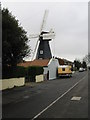
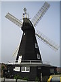
2
Drapers Windmill, St Peter's Footpath, Margate
Grade II Listed four-storey smock-type windmill, one of three that stood on the site. It was built in 1845, by John Holman, millwright of Canterbury and worked solely by wind until 1916 and then by a 20 horsepower (15kW) gas engine until the late 1930s. The sweeps and fantail were removed in 1927. The Drapers Windmill Trust was formed in 1965 when it was threatened with demolition and in 1968 the Kent Education Committee acquired the Mill, which was restored at a cost of over £2,000.00. One pair of sweeps were fitted December 1971 and a second pair from Black Mill at Barham were adapted to fit by millwright Vincent Pargeter and fitted in 1974. Now in the care of Kent County Council who are fully supported by the Drapers Windmill Trust who are responsible for the day to day running and restoration of the Mill.
Image: © Jo and Steve Turner
Taken: 7 Jul 2016
0.05 miles
3
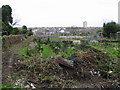
Winter tidying at the allotments
Allotments at the end of the road, St Peter's Footpath, which turns into a footpath from here.
Image: © Nick Smith
Taken: 22 Mar 2008
0.05 miles
4
Drapers Mill
Built in 1845 and restored between 1965-75 by The Drapers Mill Trust
Image: © Nick Smith
Taken: 22 Mar 2008
0.05 miles
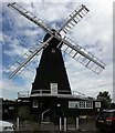
5
Cliftonville: Drapers Mill
The mill is, unsurprisingly, a prominent landmark on the metalled road section of St Peter's Footpath.
Image: © Nigel Cox
Taken: 7 Jun 2007
0.06 miles
6
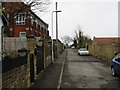
St Peter's Footpath where it becomes a small road
The building on the left is the Drapers Mills Primary school.
Image: © Nick Smith
Taken: 22 Mar 2008
0.06 miles
7
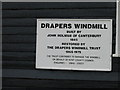
Sign for Drapers Mill
IMPORTANT.
The telephone number in this image is no longer in use by the Drapers Windmill Trust. Please do not use.
Image: © Nick Smith
Taken: 22 Mar 2008
0.06 miles
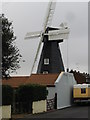
8
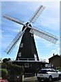
Drapers Windmill, Margate
Built in 1845, Drapers Mill is the only survivor of a line of mills which once graced this high point above Margate. It is an octagonal tarred smock-type mill and is a Grade II listed building. https://britishlistedbuildings.co.uk/101351087-drapers-windmill-thanet#.W6fJEvZFw5s
Image: © G Laird
Taken: 14 Sep 2018
0.06 miles
9

Railway to Margate
As seen from Image
This line leads from Broadstairs to Margate.
Image: © David Anstiss
Taken: 20 Feb 2011
0.07 miles
10

Looking SE along St Peter's Footpath
The small road leading to this point ends in a turning space and then becomes this path and cycle track.
Image: © Nick Smith
Taken: 22 Mar 2008
0.08 miles