IMAGES TAKEN NEAR TO
Sunrise Close, MARGATE, CT9 2QZ
Introduction
This page details the photographs taken nearby to Sunrise Close, CT9 2QZ by members of the Geograph project.
The Geograph project started in 2005 with the aim of publishing, organising and preserving representative images for every square kilometre of Great Britain, Ireland and the Isle of Man.

There are currently over 7.5m images from over14,400 individuals and you can help contribute to the project by visiting https://www.geograph.org.uk
Image Map (Loading...)


Getting Data...Please wait
Leaflet Map data © OpenStreetMap
Images are licensed for reuse under creativecommons.org/licenses/by-sa/2.0
Notes
- Clicking on the map will re-center to the selected point.
- The higher the marker number, the further away the image location is from the centre of the postcode.
Image Listing (15 Images Found)
Images are licensed for reuse under creativecommons.org/licenses/by-sa/2.0
Image
Details
Distance
5
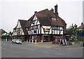
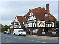
Cliftonville: Ye Olde Charles Public House
The Charles in question is King Charles I, but the building is a typical mock Tudor community pub, built in 1926 by Russell's Brewery of Gravesend on Northdown Road. The pub has an embryonic (June 2007) website here http://www.yeoldecharles.co.uk/
Image: © Nigel Cox
Taken: 7 Jun 2007
0.20 miles