IMAGES TAKEN NEAR TO
Upper Dane Road, MARGATE, CT9 2LX
Introduction
This page details the photographs taken nearby to Upper Dane Road, CT9 2LX by members of the Geograph project.
The Geograph project started in 2005 with the aim of publishing, organising and preserving representative images for every square kilometre of Great Britain, Ireland and the Isle of Man.

There are currently over 7.5m images from over14,400 individuals and you can help contribute to the project by visiting https://www.geograph.org.uk
Image Map
Images are licensed for reuse under creativecommons.org/licenses/by-sa/2.0
Notes
- Clicking on the map will re-center to the selected point.
- The higher the marker number, the further away the image location is from the centre of the postcode.
Image Listing (23 Images Found)
Images are licensed for reuse under creativecommons.org/licenses/by-sa/2.0
Image
Details
Distance
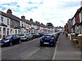
5
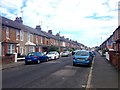
Margate: Glencoe Road
Victorian terraced houses to the south-east of Dane Park.
Image: © Nigel Cox
Taken: 7 Jun 2007
0.13 miles
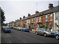
8
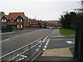
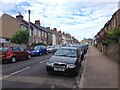
View along College Road
The road junction is St Peters Footpath, which starts life as a small road and shortly becomes a footpath only.
Image: © Nick Smith
Taken: 22 Mar 2008
0.17 miles
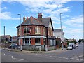
9
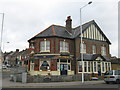
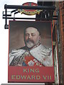
King Edward VII Public House, Margate
Shepherd Neame pub on the junction of Dane Valley Road (in front) and Millmead Road (on the left).
Image: © David Anstiss
Taken: 11 Sep 2010
0.18 miles