IMAGES TAKEN NEAR TO
Surrey Road, MARGATE, CT9 2JT
Introduction
This page details the photographs taken nearby to Surrey Road, CT9 2JT by members of the Geograph project.
The Geograph project started in 2005 with the aim of publishing, organising and preserving representative images for every square kilometre of Great Britain, Ireland and the Isle of Man.

There are currently over 7.5m images from over14,400 individuals and you can help contribute to the project by visiting https://www.geograph.org.uk
Image Map
Images are licensed for reuse under creativecommons.org/licenses/by-sa/2.0
Notes
- Clicking on the map will re-center to the selected point.
- The higher the marker number, the further away the image location is from the centre of the postcode.
Image Listing (77 Images Found)
Images are licensed for reuse under creativecommons.org/licenses/by-sa/2.0
Image
Details
Distance
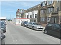
1

1, 3 & 5, Surrey Road
Compared with Image, this terrace of houses is now occupied.
Image: © John Baker
Taken: 13 Jan 2016
0.01 miles
2
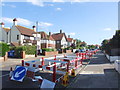
New dwellings under construction, Surrey Road
They are being built following the Image The site is part of a long-term programme called ‘Live Margate’ that Thanet District Council has set up which involves buying existing properties and turning them into quality family homes. The buildings that are being targeted are those that have been derelict and unoccupied for years http://thanet.gov.uk/the-thanet-magazine/campaigns/live-margate/
Image: © John Baker
Taken: 22 Jun 2014
0.01 miles
3
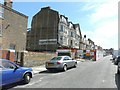
Demolition of Leslie Hotel, Surrey Road
The view was taken looking southeast. Planning permission has been granted by Thanet District Council under application number F/TH/12/0227 for the “erection of five dwellings following demolition of existing building”.
Image: © John Baker
Taken: 28 Jul 2013
0.01 miles
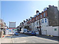
4
Demolition of Leslie Hotel, Surrey Road
View was taken looking north-northeast. Planning permission has been granted by Thanet District Council under application number F/TH/12/0227 for the “erection of five dwellings following demolition of existing building”.
Image: © John Baker
Taken: 28 Jul 2013
0.01 miles
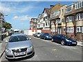
6

1, 3 & 5, Surrey Road
There is a sign, on the side wall of number 1, pointing to Nautical Mews.
Image: © John Baker
Taken: 13 Jan 2016
0.02 miles
7
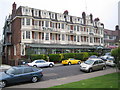
Cliftonville: Walpole Bay Hotel
This hotel was built on Fifth Avenue in 1914, and many of its original features have been preserved such that the building is literally a Living Museum. For much further information the hotel's website is here http://www.walpolebayhotel.co.uk/index.html
Image: © Nigel Cox
Taken: 7 Jun 2007
0.04 miles
9
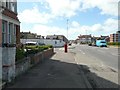
Eastern Esplanade
The postbox on the pavement is on the corner of Surrey Road (to its left), while, across the road, white hoarding hides a site devoid of buildings, which Thanet District Council has granted planning permission for, and is described under the planning application F/TH/05/0018 as the “erection of block of 87 flats and associated undercroft car parking”. The location was described as St. Georges Hotel .
Image: © John Baker
Taken: 28 Jul 2013
0.05 miles
10
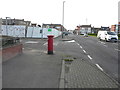
Looking west along Eastern Esplanade
This is a similar view of Image taken towards the end of July 2013. However the “for sale” details, stuck to the hoarding, relate to Clarke & Crittenden, which is a family run firm of Chartered Surveyors specialising in the South-East of England http://www.clarke-crittenden.com/
Planning permission has been granted by Thanet District Council under application number F/TH/05/0018 for the “erection of block of 87 flats and associated undercroft car parking”. The site used to be occupied by St. Georges Hotel.
Image: © John Baker
Taken: 13 Jan 2016
0.05 miles