IMAGES TAKEN NEAR TO
Gordon Road, MARGATE, CT9 2DW
Introduction
This page details the photographs taken nearby to Gordon Road, CT9 2DW by members of the Geograph project.
The Geograph project started in 2005 with the aim of publishing, organising and preserving representative images for every square kilometre of Great Britain, Ireland and the Isle of Man.

There are currently over 7.5m images from over14,400 individuals and you can help contribute to the project by visiting https://www.geograph.org.uk
Image Map
Images are licensed for reuse under creativecommons.org/licenses/by-sa/2.0
Notes
- Clicking on the map will re-center to the selected point.
- The higher the marker number, the further away the image location is from the centre of the postcode.
Image Listing (132 Images Found)
Images are licensed for reuse under creativecommons.org/licenses/by-sa/2.0
Image
Details
Distance
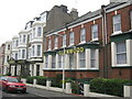

5
Elizabeth Anne Nursing and Residential Care Home, 64, Elgar Road
The name of this former institution can be seen on the black “triangle” above the hoarding. This was probably situated over the front entrance. The boarded up windows, on the first floor, indicate that the building is disused.
Image: © John Baker
Taken: 13 Jan 2016
0.06 miles
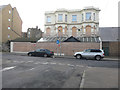
6

64, Edgar Road
Planning permission has been granted by Thanet District Council under application number F/TH/17/0842 for the “change of use and extension of former residential home (use class C2) along with the erection of a 5 storey building to create twelve 2-bedroom and three 3-bedroom apartments and associated works together with the demolition of existing extensions”.
Image: © John Baker
Taken: 9 Dec 2018
0.06 miles
7
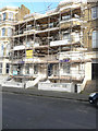
Renovation of 25, Dalby Square
Two information boards, affixed to the scaffolding boards on the first floor, read “the Dalby Square Townscape Heritage Initiative Scheme”.
The Dalby Square, Cliftonville, Townscape Heritage Initiative (THI) Grant Scheme began in January 2013 and will run until January 2018. It is funded 75% by the Heritage Lottery Fund with 25% match funding from Thanet District Council.
The objectives of the Dalby Square, Cliftonville Townscape Heritage Initiatives are to: raise awareness of the value and quality of the historic built environment. Promote the repair of historic buildings in the conservation area using appropriate materials, detailing and workmanship. Set an example of good practice in building conservation. Reinforce an area's unique identity. Help change residents' and visitors' perceptions of Cliftonville West
https://www.thanet.gov.uk/your-services/regeneration/townscape-heritage-initiative-grant-schemes/dalby-square-cliftonville-thi-project/
Image: © John Baker
Taken: 13 Jan 2016
0.07 miles
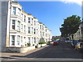
8
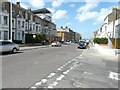
Sweyn Road
Taken from the corner of Albion Road, looking across the road to numbers 40-46, one of which appears to be having a new roof, as indicated by the scaffolding that was erected above it. However, closer inspection revealed that these numbers appeared to be derelict.
Image: © John Baker
Taken: 28 Jul 2013
0.08 miles
9
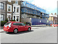
40-46, Sweyn Road
Planning permission has been granted by Thanet District Council under application number F/TH/15/0207 for a “change of use and conversion to 2 four bed dwellings, 2 two bed flats and 2 two bed maisonettes, erection of 2 single storey rear extensions, and alterations to front elevation, following demolition of single storey front and rear extensions and second floor extension to rear”.
The houses can also be seen in this image of Image but from further away.
Image: © John Baker
Taken: 30 Jul 2017
0.08 miles
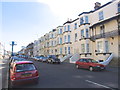
10
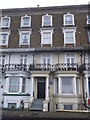
7 Ethelbert Crescent, Cliftonville
One of the terrace of houses along a road.
Has Image on the side.
Image: © David Anstiss
Taken: 9 Apr 2013
0.08 miles