IMAGES TAKEN NEAR TO
Clifton Gardens, MARGATE, CT9 2BL
Introduction
This page details the photographs taken nearby to Clifton Gardens, CT9 2BL by members of the Geograph project.
The Geograph project started in 2005 with the aim of publishing, organising and preserving representative images for every square kilometre of Great Britain, Ireland and the Isle of Man.

There are currently over 7.5m images from over14,400 individuals and you can help contribute to the project by visiting https://www.geograph.org.uk
Image Map
Images are licensed for reuse under creativecommons.org/licenses/by-sa/2.0
Notes
- Clicking on the map will re-center to the selected point.
- The higher the marker number, the further away the image location is from the centre of the postcode.
Image Listing (155 Images Found)
Images are licensed for reuse under creativecommons.org/licenses/by-sa/2.0
Image
Details
Distance
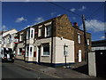
2
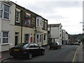
The Good Intent Public House, Margate
On 34 Bath Road.
Image: © David Anstiss
Taken: 11 Sep 2010
0.03 miles

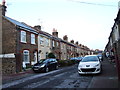
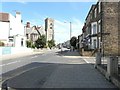
5
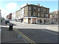
Northdown Road
Its junction with Athelstan Road is seen on the right, while opposite it is its junction with Clifton Gardens.
Image: © John Baker
Taken: 28 Jul 2013
0.05 miles
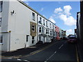
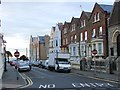
8
Block on Northdown Road, Margate
Built around 1900.
Image: © Robin Webster
Taken: 20 Mar 2016
0.05 miles
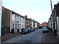
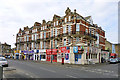
9
Northdown Road
Taken from the corner of Clifton Road, with St Paul's church prominent on the left.
Image: © John Baker
Taken: 28 Jul 2013
0.06 miles