IMAGES TAKEN NEAR TO
Bath Road, MARGATE, CT9 1SL
Introduction
This page details the photographs taken nearby to Bath Road, CT9 1SL by members of the Geograph project.
The Geograph project started in 2005 with the aim of publishing, organising and preserving representative images for every square kilometre of Great Britain, Ireland and the Isle of Man.

There are currently over 7.5m images from over14,400 individuals and you can help contribute to the project by visiting https://www.geograph.org.uk
Image Map
Images are licensed for reuse under creativecommons.org/licenses/by-sa/2.0
Notes
- Clicking on the map will re-center to the selected point.
- The higher the marker number, the further away the image location is from the centre of the postcode.
Image Listing (166 Images Found)
Images are licensed for reuse under creativecommons.org/licenses/by-sa/2.0
Image
Details
Distance

2
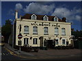
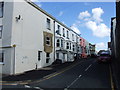
The Mulberry Tree, Dane Road
Pub on the junction with Bath Road
Image: © Keith Edkins
Taken: 22 Jun 2015
0.04 miles
3
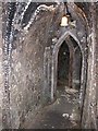
The Shell Grotto, Grotto Hill, Margate
This strange, underground grotto was discovered in 1835. It was opened to the public in 1838 and is now a Grade I listed building which remains a tourist attraction. Although there are many theories on the Grotto's origins, who made it, when or why remain mysteries. It contains 4.6 million shells (I wonder who counted them) and, although in need of cleaning, a way of doing this without destroying the shells has yet to be discovered.
Image: © pam fray
Taken: 3 Aug 2011
0.04 miles

6
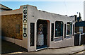
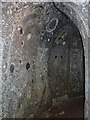
Margate : entrance, Shell Grotto
The Grotto is Grade I listed - description at this https://historicengland.org.uk/listing/the-list/list-entry/1341537?section=official-list-entry.
Image: © Jim Osley
Taken: 19 Mar 2022
0.05 miles
7
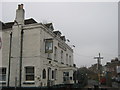
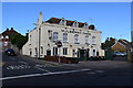
The Mulberry Tree, Public House, Margate
Pub on the junction of Grotto Hill (on the left) and Dane Road (on the right).
Image: © David Anstiss
Taken: 20 Feb 2011
0.05 miles
8
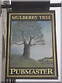
The Mulberry Tree, Pub Sign, Margate
On Image
Image: © David Anstiss
Taken: 20 Feb 2011
0.05 miles